%20(COPY)%20Tutorial%20thumbnail.jpeg)
Here it is! Our latest functionality called: Workspaces!
The introduction of this new functionality was purely the result of enthusiastic user feedback who had been asking for it to help them have a more professional and organized management for their virtual tours. The most critical problem we are trying to solve here is the necessity for multiple departments or customers to reach only certain tours without the problem of dealing with a messy interface.
Let me explain briefly for you how to do it! It is pretty straightforward! Here’s a short guide:
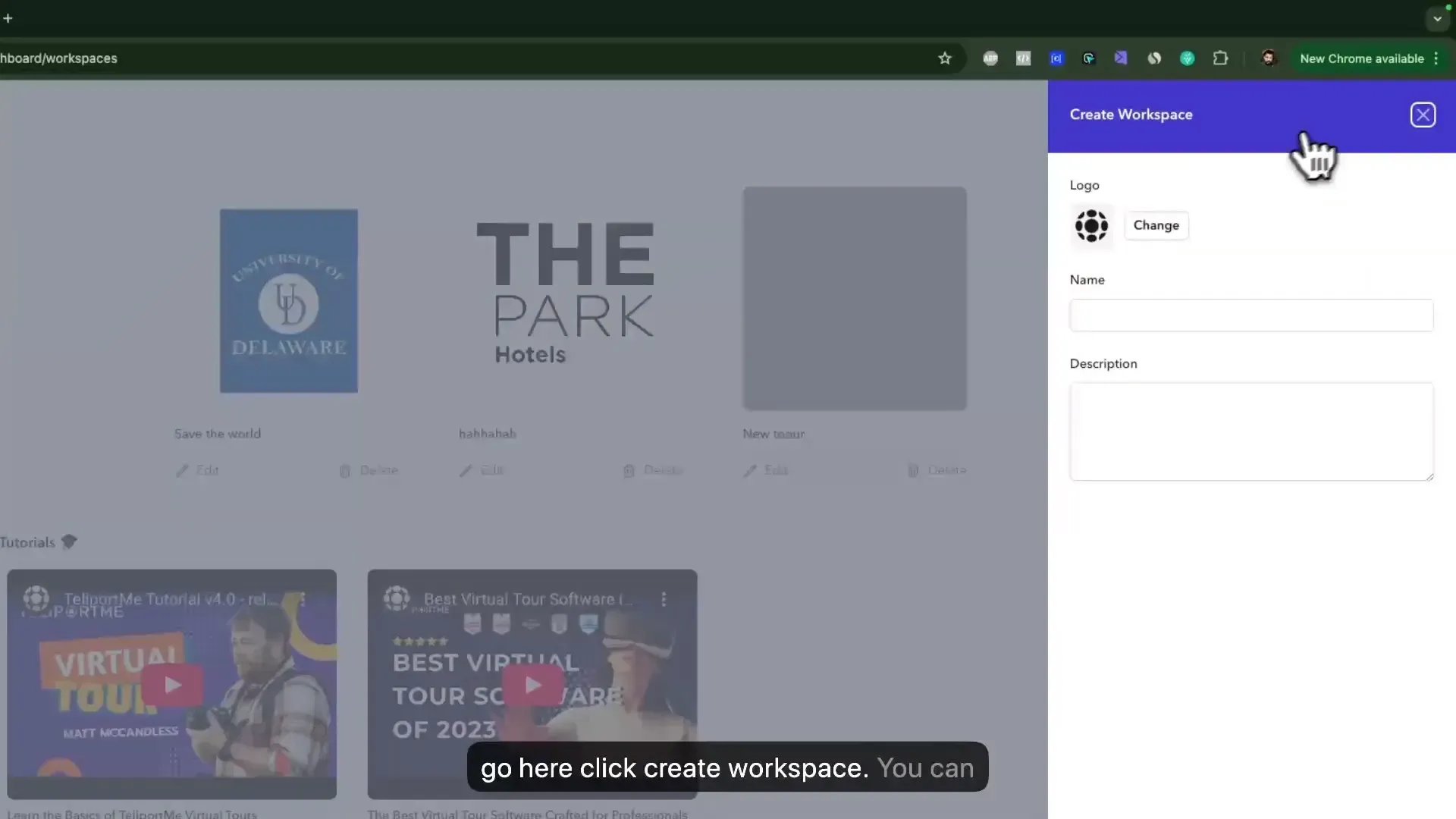
- Create a Workspace: Click on 'Create Workspace', customize it by adding a logo, name, and description, then hit save.
- Add Team Members: You can add as many team members as your plan allows. Each member can be assigned a specific role tailored to that workspace.
- Define Roles: Roles are workspace-specific. For example, a team member can be an editor in one workspace and a creator in another.
- Create and Manage Tours: You can create new tours directly within the workspace or add existing tours by selecting them and moving them to the desired workspace.
Let’s illustrate this with a use case.
Imagine a real estate agency managing multiple agents and their properties. With Workspaces, they can create a dedicated workspace for each agent, allowing team members (photographers, editor and agents) to collaborate efficiently. One member could be responsible for editing the tours, while another could manage client access, ensuring that only relevant tours are visible to specific clients. This streamlined approach not only enhances productivity but also improves client satisfaction.
Agencies and schools will find it very easy to use the app as an online assignment platform with features that allow them to create a workspace for their individual needs. It is also important for organizations to focus more and more on cyber security, thus, a marketing agency can establish separate workspaces for each client in the system and there they can manage permissions and access, ensuring complete confidentiality of the work materials. Likewise, a school can set up different workspaces for departments allowing faculty and students to collaborate effectively.
The Workspaces feature is tailored to fit your team's needs. The Business plan includes access to one extra workspace while the Unlimited plan consists of three workspaces as your part of your subscription plan. If you need additional workspaces, you can easily do that by adding them for a one-time fee of $199 for Business plan users and $159 for Unlimited plan users.
We encourage you to explore this new feature and transform the way you manage your virtual tours.
]]>Virtual Tour Software Market:
%20YouTube%20Thumbnail%201280x720%20px%20(3).jpeg)
The virtual tour software market has seen rapid expansion, driven by the growing need for immersive online experiences. Businesses across real estate, hospitality, education, and retail are leveraging this technology to enhance customer engagement and streamline decision-making processes. High-quality virtual tours provide users with interactive, 360-degree views of spaces, eliminating geographical barriers and offering a seamless digital experience.
Real estate firms utilize virtual tours to showcase properties remotely, reducing the need for on-site visits. Hotels and travel companies create lifelike previews of destinations and accommodations, helping customers make informed booking decisions. Educational institutions integrate interactive campus tours to attract prospective students, while retailers enhance e-commerce platforms with virtual showrooms. These applications demonstrate the market’s increasing relevance across multiple sectors.
Businesses adopting virtual tour solutions report higher customer engagement and improved conversion rates. By offering an immersive visualization of spaces, virtual tour technologies build consumer confidence, leading to more informed purchasing decisions. As digital engagement continues to evolve, the demand for sophisticated and user-friendly virtual tour software will continue its upward trajectory.
Leading Virtual Tour Software Providers
The virtual tour software market includes several key players, each offering unique features tailored to different industries. The following providers stand out due to their technological advancements, usability, and market reach.
Matterport
Matterport dominates the virtual tour industry with its 3D scanning technology and AI-powered automation. Its software supports high-resolution 3D models that enhance real estate, architecture, and retail applications. The proprietary Pro3 camera allows for precise imaging, while integrations with platforms like Zillow and Realtor.com enhance accessibility.
- Strengths: AI-generated 3D tours, immersive dollhouse view, automated floor plans.
- Limitations: Higher cost compared to competitors, requires proprietary hardware for best results.
TeliportMe
Teliportme provides a high resolution, cost-effective alternative to Matterport with a strong focus on customization. It supports 360-degree photo uploads and interactive hotspots, making it popular among photographers and real estate agents. Its compatibility with various image file types and an intuitive drag-and-drop interface simplify tour creation.
- Strengths: Affordable pricing, flexible customization, smooth web integration, unlimited 3D dollhouse
- Limitations: Lacks native 3D scanning.
3DVista
Known for its high-quality rendering and extensive multimedia features, 3DVista appeals to professionals in real estate, tourism, and education. It supports live-guided tours, animated hotspots, and VR compatibility without requiring proprietary hardware.
- Strengths: Advanced interactivity, customizable branding, extensive multimedia support.
- Limitations: Steeper learning curve, desktop-based software rather than cloud-based.
Pano2VR
Pano2VR targets users needing deep customization and compatibility with GIS data. It specializes in high-resolution spherical panoramas with full VR and HTML5 support, making it ideal for architects and urban planners.
- Strengths: GIS compatibility, customizable interface, high-resolution outputs.
- Limitations: More technical setup required, lacks AI automation.
Kuula
Kuula's web-based interface simplifies virtual tour creation, offering drag-and-drop functionality and white-label branding options. It primarily serves real estate professionals, auto dealerships, and hospitality businesses looking for cloud-hosted virtual experiences.
- Strengths: Browser-based solution, ease of use, strong mobile compatibility.
- Limitations: Limited 3D rendering capabilities, fewer advanced editing tools.
Choosing the Right Platform
Each virtual tour software provider caters to different needs. Matterport excels in AI-driven automation and real estate integrations, while Teliportme.com offers affordability, ease of use and suits businesses needing a fast cloud-based solution with minimal setup. 3DVista and Pano2VR provide advanced customization for niche applications like GIS and interactive media. Buyers must align their selection with project requirements, budget, and required technical capabilities.
Industry Applications of Virtual Tour Software
Businesses and organizations across multiple industries integrate virtual tour software to improve user engagement, streamline operations, and boost sales. Real estate companies showcase properties remotely, educational institutions enhance learning experiences, and travel brands create interactive previews of destinations. Each sector leverages this technology in unique ways to meet industry-specific needs.
Real Estate: Virtual Property Showings and Open Houses
Real estate professionals use virtual tours to provide potential buyers and renters with immersive property experiences. These digital showings reduce the need for in-person visits, increasing engagement and accelerating decision-making processes. According to a 2023 study by the National Association of Realtors (NAR), 67% of homebuyers prefer virtual tours when evaluating properties online.
- 360-Degree Property Views: Buyers navigate through homes as if they were physically present.
- Remote Client Engagement: Agents connect with international or out-of-state buyers without scheduling physical tours.
- Time Efficiency: Realtors eliminate unnecessary site visits, focusing on serious buyers.
- Virtual Staging: Unfurnished properties appear fully furnished through digital modeling, enhancing appeal.
Commercial real estate firms also adopt this technology for leasing office spaces, allowing potential tenants to assess layouts and designs remotely.
Education: Virtual Campus Tours and Online Learning Enhancements
Universities and schools integrate virtual tour software to attract prospective students and support digital learning. A 2022 report from Inside Higher Ed states that 58% of students factor virtual tours into their application decisions.
- Campus Exploration: Students explore academic buildings, dormitories, and recreational areas without traveling.
- Interactive Learning Modules: Educators use immersive simulations for history lessons, science experiments, and engineering demonstrations.
- Student Recruitment: Admissions teams engage international or remote students more effectively through digital tours.
- Augmented Reality (AR) Enhancements: Classroom lectures integrate AR-based virtual field trips for deeper subject engagement.
In corporate training, businesses adopt similar tools to provide realistic onboarding experiences and employee learning simulations.
Travel and Hospitality: Interactive Hotel and Destination Tours
Hotels, resorts, and tourism agencies employ virtual tours to boost bookings and provide realistic previews of travel destinations. A 2023 study by HospitalityNet reveals that hotels with virtual tours report a 16% increase in direct bookings.
- Hotel Room Previews: Guests explore accommodations in detail before making reservations.
- Resort and Cruise Ship Walkthroughs: Travel operators showcase amenities, dining areas, and entertainment facilities.
- Destination Experiences: Tourism boards create interactive city tours, historical site walkthroughs, and adventure previews.
- Event Venue Marketing: Convention centers, wedding halls, and stadiums attract bookings by offering 3D interactive venue previews.
Airbnb and vacation rental platforms also incorporate virtual tours to provide transparency and set accurate expectations for potential travelers.
Benefits of Using Virtual Tour Software
Enhancing Customer Experience and Engagement
High-quality virtual tours create immersive environments that engage users more effectively than static images or text descriptions. A study by Google found that listings with virtual tours receive twice the engagement compared to those without.
Interactive elements such as clickable points, embedded videos, and real-time audio guides keep users engaged for longer sessions. This increased interaction boosts customer confidence and decision-making, particularly in industries like real estate, tourism, and retail.
Reducing Operational Costs for Businesses
Virtual tour software minimizes the need for physical site visits, cutting travel expenses and operational costs for businesses. According to a report by Matterport, real estate agents using virtual tours reduce time on market by up to 31% and lower staging costs since digital representations showcase properties effectively.
- Retailers save on showroom expenses by offering virtual storefronts.
- Museums and attractions reduce staffing needs for on-site tours.
- Universities use virtual campus tours to cut down recruitment travel costs.
Improving Accessibility to Properties and Locations
Virtual tours break geographical barriers, granting remote access to properties, businesses, and attractions. Nearly 75% of potential buyers prefer listings with virtual tours, according to Redfin, as they enable informed decisions without in-person visits.
Beyond real estate, industries such as hospitality and education leverage this technology. Hotels showcase rooms, conference venues display event spaces, and universities offer remote campus explorations—providing audiences with an in-depth, interactive experience regardless of location.
Key Features of Virtual Tour Software
Interactive Elements and Virtual Reality (VR) Integration
Virtual tour software enhances user engagement with interactive elements such as clickable hotspots, embedded multimedia, and guided narration. These elements allow users to explore spaces at their own pace, accessing additional details with a single click.
VR integration takes immersion further by enabling users to experience tours with head-mounted displays like the Meta Quest 3, HTC Vive, or Pico 4. High-resolution 3D modeling and stereoscopic rendering create environments that feel lifelike, significantly boosting engagement and retention.
Customization Options for Different Business Needs
Businesses require tailored solutions, and virtual tour software provides extensive customization options. Branding elements like logos, color schemes, and fonts can be integrated seamlessly to ensure a cohesive visual identity.
- Navigation Controls: Adjustable viewpoints, maps, and customizable menus for an optimal browsing experience.
- Multimedia Embeds: Video, audio, and detailed descriptions enrich the tour experience.
- Lead Generation Tools: Contact forms, chat integrations, and analytics dashboards help convert viewers into customers.
Advanced solutions also support white-labeling, allowing businesses to present tours under their brand without third-party branding.
Compatibility with Various Devices and Platforms
Users access virtual tours from desktops, tablets, smartphones, and VR headsets. Cross-device compatibility ensures a consistent experience regardless of screen size or operating system.
Web-based platforms, often developed with WebGL and HTML5, eliminate the need for additional software downloads, making tours accessible directly from a browser. Mobile responsiveness ensures that touch gestures, such as pinch-to-zoom and swipe navigation, function smoothly on smaller screens.
For businesses managing large-scale implementations, cloud-based hosting solutions provide scalable storage and reliable content delivery, ensuring fast load times and minimal downtime.
Integration with Other Technologies:
Virtual tour software integrates with immersive technologies to create interactive experiences. VR (Virtual Reality) provides full immersion, AR (Augmented Reality) overlays digital elements onto the real world, and 360-degree cameras capture the complete environment for seamless navigation.
- Virtual Reality (VR): VR headsets such as the Meta Quest 3 and HTC Vive allow users to explore digital spaces with life-like depth and spatial accuracy. Virtual tour platforms output VR-compatible files, enabling smooth rendering on these devices.
- Augmented Reality (AR): AR-capable mobile apps overlay additional information—such as text annotations or 3D objects—onto real-world images. Users scan QR codes or markers to activate contextual digital content.
- 360-Degree Cameras: Cameras like the Ricoh Theta's and Insta360's capture fully spherical images and videos. Virtual tour software processes this content, stitching together seamless visual environments.
The Role of Emerging Technologies in Enhancing Virtual Tour Experiences
AI-powered automation, cloud rendering, and high-resolution imaging refine virtual tour quality. These technologies improve navigation, interaction, and accessibility.
- AI-Based Enhancements: Machine learning optimizes image processing, corrects color inconsistencies, and generates automated scene descriptions for accessibility.
- Cloud Rendering: Cloud-based processing enables high-resolution rendering without hardware limitations. Platforms like AWS and Google Cloud streamline real-time virtual tour delivery.
- Haptic Feedback: Haptic-enabled VR environments add tactile sensations to virtual spaces, increasing engagement for real estate, tourism, and education sectors.
- LiDAR and Depth Sensing: Devices like the iPhone 15 Pro use LiDAR to capture spatial depth, enhancing virtual tours with realistic perspective and dimensional accuracy.
These integrations expand functionality and broaden virtual tour applications, making them more immersive, interactive, and adaptable across industries.
User Experience and Interface Design
Intuitive Design Enhances Customer Engagement
Users engage more when virtual tour interfaces are intuitive and responsive. Complex menus and unclear navigation reduce interaction time, while streamlined layouts encourage extended exploration. In a 2023 study by Grand View Research, user-friendly virtual experiences saw a 35% increase in engagement compared to less intuitive designs.
Interactive elements, such as clickable hotspots and guided narration, hold visitor attention. Tours with high interaction rates generate more leads in real estate, tourism, and education. A study by HubSpot indicates that websites with interactive elements increase average session duration by up to 47%, leading to better conversion rates.
Best Practices for a Seamless Virtual Tour Interface
- Simple Navigation: Users expect a clear path through virtual spaces. Breadcrumb trails and minimaps reduce disorientation, ensuring fluid movement.
- Fast Loading Speeds: Lag disrupts the experience. Compression techniques and content delivery networks (CDNs) minimize load times, keeping users engaged.
- Mobile Responsiveness: Over 55% of virtual tour traffic comes from mobile devices, as reported by Statista. Designs must adjust seamlessly across screen sizes.
- High-Quality Visuals: Blurred or pixelated images break immersion. Optimizing resolution while maintaining fast performance ensures a compelling experience.
- Minimalist UI Design: Overloaded interfaces overwhelm users. A clean, distraction-free layout highlights key interactive features.
- Accessibility Features: Subtitles, high-contrast modes, and keyboard navigation options accommodate diverse user needs.
Consistent refinement improves virtual tours over time. User behavior analytics reveal interaction patterns, allowing developers to optimize interfaces. Feedback loops and usability testing further refine engagement strategies for sustained success.
Cost Analysis and Pricing Models in the Virtual Tour Software Market
Breakdown of Costs Associated with Virtual Tour Software
Virtual tour software costs vary widely based on features, scalability, and licensing models. The main expenses fall into a few key categories:
- Software Licensing Fees: Prices range from $10 per month for basic plans to over $500 monthly for enterprise solutions.
- Hosting and Storage: Cloud-based platforms often include storage, but additional bandwidth or high-resolution content may incur extra fees.
- Customization and Branding: White-label solutions typically cost more, with one-time fees or increased monthly rates.
- Hardware Costs: While some platforms work with standard cameras, high-end virtual tours may require 360-degree cameras or VR headsets.
- Support and Training: Advanced customer support, onboarding assistance, or developer integrations can add to the total cost.
Overview of Different Pricing Models
Virtual tour software providers structure pricing plans around subscription tiers, one-time licenses, and usage-based models. Businesses should align their budget with their specific needs.
- Subscription-Based Pricing: Monthly or annual payments provide ongoing access to the platform. Plans typically range from $10 to $200 per month, with enterprise options exceeding $500.
- One-Time License Fees: Some providers offer perpetual licenses, requiring a single upfront payment. These can start at $500 and scale up based on features.
- Pay-Per-Tour or Usage-Based Pricing: Platforms charging per virtual tour or per project often set rates between $5 and $50 per tour, with additional fees for hosting.
- Freemium Models: Basic functionality is available for free, but premium features require an upgrade. These models help small businesses test the platform before committing.
Price differences arise from included features, audience size, and integration capabilities. Businesses evaluating virtual tour software should consider scalability and long-term cost efficiency.
Adoption Rate and Market Growth Statistics
Expanding Adoption Across Industries
Virtual tour software adoption has surged across multiple sectors. Real estate, hospitality, education, and retail have been quick to integrate these tools, driving significant market growth. The real estate industry leads the adoption curve, with 77% of buyers preferring virtual tours before visiting properties physically, according to the National Association of Realtors (NAR).
In education, universities and schools have implemented virtual tour solutions to engage prospective students. A report from Grand View Research estimates that the global e-learning market, which includes virtual campus tours, will grow at a CAGR of 14.6% from 2022 to 2030.
Market Size and Growth Projections
The virtual tour software market has witnessed rapid expansion, with market size estimates reflecting its rising adoption. According to a report by Markets and Markets, the immersive technology sector, including virtual tours, was valued at $7.9 billion in 2021 and is projected to reach $26.5 billion by 2027, growing at a CAGR of 18.2%.
North America dominates the market due to widespread digital adoption, while the Asia-Pacific region is experiencing the highest growth rate. Countries like China, Japan, and India are investing heavily in virtual reality (VR) and augmented reality (AR), further propelling virtual tour adoption.
Key Trends Driving Market Growth
- Increased Consumer Demand: 360-degree tours and interactive walkthroughs have become standard expectations in industries like real estate and tourism.
- Advancements in VR and AR: The integration of virtual and augmented reality enhances user engagement, making these experiences more immersive.
- Cloud-Based Solutions: SaaS-based virtual tour platforms have lowered entry barriers, driving adoption among small and medium enterprises (SMEs).
- Mobile Optimization: Over 60% of virtual tour engagement now happens on mobile devices, pushing developers towards mobile-first solutions.
- Artificial Intelligence (AI) Integration: AI-powered personalization features enhance the user journey, enabling automated property recommendations and interactive guides.
Projected Market Expansion
Analysts foresee continued momentum in the virtual tour software market. A report by Statista indicates that global spending on VR and AR solutions, including virtual tours, will surpass $72.8 billion by 2024. The adoption of metaverse-related applications is expected to further accelerate demand, particularly in retail and corporate training sectors.
As businesses recognize the competitive advantage of offering immersive experiences, investment in virtual tour technologies will continue its upward trajectory. The next decade will see even greater innovation, widening accessibility and adoption across new industries.
Customer Engagement and Marketing Strategies with Virtual Tours
Virtual Tours as a Powerful Marketing Tool
Virtual tours transform the way businesses attract and engage customers. They offer an immersive experience that enables potential clients to explore a space or product remotely, leading to longer engagement times and increased conversion rates. According to a study by Google, listings with virtual tours generate 87% more views than those without.
Industries like real estate, hospitality, and retail utilize virtual tours to showcase properties, hotel rooms, and product showrooms without requiring a physical visit. The ability to immerse potential customers in a 360-degree environment creates a sense of familiarity and trust, directly influencing purchase decisions.
Strategies to Increase Customer Interaction Through Virtual Tours
Integrating Virtual Tours into Digital Marketing Campaigns
Embedding virtual tours in websites, social media, and email marketing campaigns enhances visibility and engagement rates. Studies by Pew Research Center indicate that interactive content generates up to 2x more engagement than static content. Leveraging virtual tours in paid ads and social media boosts engagement and click-through rates by offering interactive experiences that captivate audiences.
Gamification and Interactive Elements
Adding interactive hotspots, quizzes, or rewards within the virtual tour enhances user engagement. Businesses can include clickable call-to-action (CTA) buttons that direct visitors to booking pages, product pages, or lead capture forms. The integration of gamification elements increases dwell time, improving SEO rankings and user retention.
Personalized Customer Journey
Businesses that tailor virtual tours to individual preferences see higher engagement and conversion rates. Advanced analytics tools track user interactions, allowing companies to adjust virtual content in real time. Personalized recommendations based on viewing behavior make the tour more relevant, leading to a direct impact on sales conversions.
SEO and Visibility Benefits
Search engines prioritize interactive and media-rich content. Hosting virtual tours on business websites improves dwell time, reduces bounce rates, and enhances search engine rankings. Studies show that websites featuring virtual tours experience up to a 40% increase in organic traffic, making them a valuable marketing asset.
Embedding Virtual Tours in Customer Support
Companies use virtual tours to enhance customer support by providing detailed walkthroughs of products, equipment, or services. A hands-on guided experience reduces reliance on traditional support channels, decreasing ticket volumes and improving overall customer satisfaction.
Social Proof and User-Generated Content
Businesses encourage customers to share their virtual tour experiences on social media. This generates organic reach and builds credibility. According to HubSpot, user-generated content drives 28% higher engagement rates than brand-created content. Incorporating real customer testimonials within the tour adds authenticity, strengthening brand trust.
Virtual tours redefine digital marketing strategies, increasing engagement, interaction, and conversion rates across industries. The combination of interactivity, personalization, and accessibility ensures that businesses remain competitive in an evolving digital landscape.
Case Studies and Success Stories
Organizations across multiple industries have leveraged virtual tour software to enhance customer engagement, streamline operations, and drive revenue growth. Examining real-world examples highlights how businesses maximize the potential of this technology.
Real-World Success Stories
- Marriott International – Virtual Tours for Hotel Marketing- Marriott introduced immersive 360-degree virtual tours across its global hotel portfolio, leading to a 67% increase in online booking engagement. By integrating Matterport’s virtual tour technology, Marriott allowed prospective guests to explore rooms and amenities before making reservations, reducing customer hesitation.
- Century 21 – Virtual Tours in Real Estate - Century 21 implemented virtual property tours to address limitations in traditional open houses. The initiative resulted in a 49% faster closing rate and a 29% increase in high-intent inquiries. VR-enabled showings helped international buyers explore properties remotely, significantly broadening market reach.
- University of California, Berkeley – Virtual Campus ToursBy deploying YouVisit’s virtual tour software, UC Berkeley provided prospective students worldwide with interactive campus experiences. This digital approach led to a 35% rise in applications from out-of-state and international students.
- BMW – Virtual Showroom Experience- BMW launched a digital showroom powered by 3D virtual tour technology. Customers could explore vehicle features in detail, reducing showroom visits by 23% while increasing online configuration tool interactions by 42%.
Lessons Learned and Best Practices
- Enhancing Customer Confidence- Providing high-resolution, interactive walkthroughs increases user confidence, leading to stronger engagement and higher conversion rates in industries like hospitality and real estate.
- Seamless Mobile Optimization- Businesses that ensure mobile compatibility capture a wider audience. Century 21 reported a 37% rise in mobile traffic after optimizing its virtual tour experience.
- Integrating Virtual Tours with Sales Funnels- Companies linking virtual tours to booking or purchase platforms drive measurable returns. BMW's integration with its car configurator directly influenced purchase decisions.
- Adapting to Hybrid Consumer Behavior- Combining virtual and in-person interactions creates a comprehensive customer journey. Marriott’s hybrid approach of virtual previews followed by in-person visits streamlined decision-making.
These case studies demonstrate how virtual tour software reshapes consumer engagement and operational efficiencies. Businesses that adopt immersive digital experiences gain a competitive edge in their respective markets.
Trends in Virtual Tour Technology
Virtual tour software continues to evolve, integrating cutting-edge technologies that enhance realism, interactivity, and accessibility. Artificial intelligence, real-time rendering, and cloud-based solutions are redefining how businesses and consumers experience immersive environments.
- AI-Driven Automation: Machine learning algorithms now automate scene stitching, generate interactive elements, and personalize user experiences based on visitor behavior.
- Real-Time Graphics Rendering: Advances in WebGL and GPU acceleration improve image quality and smoothness, reducing latency while navigating virtual spaces.
- Cloud-Based Hosting: Scalable cloud solutions eliminate storage limitations, enabling higher-resolution tours without impacting performance.
Shifting Consumer Expectations and Experience Demands
Consumer demand for higher engagement and realism pushes the development of more interactive features within virtual tour software. Users expect an experience that mirrors real-world exploration, leading to several notable trends.
- Interactive Hotspots: More platforms now integrate clickable elements, pop-up information, and embedded multimedia to enhance engagement.
- Multi-Device Compatibility: Optimizing virtual tours for desktops, mobile devices, and VR headsets ensures seamless access across platforms.
- Social and Collaborative Exploration: Multi-user environments allow guided virtual property showings, live interactions, and real-time annotations within tour spaces.
AI-Powered Personalization and Predictive Analytics
AI is advancing beyond automation, shaping personalized virtual tour experiences. Software algorithms analyze user navigation patterns and recommend relevant content, increasing session duration and interaction rates. Predictive analytics further refines how businesses tailor their virtual environments to specific audience interests.
Extended Reality (XR) Integration
The convergence of augmented reality (AR), virtual reality (VR), and mixed reality (MR) is driving the next stage of virtual tour development. Features like AR overlays for real-world navigation and full-VR walk-throughs redefine how users engage with digital spaces.
- Augmented Reality Enhancements: Mobile-based AR allows users to visualize changes in physical environments before implementation.
- Immersive VR Exploration: Higher adoption of standalone VR headsets enables fully immersive tours with six degrees of freedom (6DoF).
- Hybrid Reality Applications: Combining AR and VR elements provides a seamless transition between digital and physical spaces.
Blockchain for Security and Authenticity
Blockchain technology enters the virtual tour space, ensuring data integrity and content authenticity. Secure decentralized storage prevents unauthorized modifications, while smart contracts verify tour ownership, benefiting industries such as real estate and digital exhibitions.
Low-Code and No-Code Virtual Tour Creation
Developments in low-code and no-code platforms make virtual tour creation more accessible. Drag-and-drop functionalities remove the need for complex coding, allowing businesses and individuals to develop high-quality immersive tours with minimal technical expertise.
Sustainability and Green Hosting Solutions
Energy-efficient hosting services and optimized processing reduce the carbon footprint of virtual tours. Companies adopt eco-friendly cloud solutions, prioritizing sustainability without compromising performance.
What’s Next?
With continuous advancements in AI, XR, and cloud computing, virtual tour software will keep pushing boundaries. Businesses that leverage these innovations stay ahead, offering users more immersive, interactive, and intelligent experiences.
Accessibility and Inclusivity Considerations in Virtual Tour Software
Ensuring Virtual Tours Are Accessible to All Users
Virtual tour software must accommodate users with diverse needs. Without accessibility features, a significant portion of the audience remains excluded. Compliance with standards like the Web Content Accessibility Guidelines (WCAG) ensures broad usability. Features like screen reader support, keyboard navigation, and adjustable text contrast improve the experience for users with visual impairments.
- Screen Reader Compatibility: Alternative text for images, clear labels for interactive elements, and structured HTML elements enable users with visual impairments to navigate tours effectively.
- Keyboard Navigation: Some users rely on keyboards rather than mice. Intuitive tab orders and focus indicators make navigation seamless.
- Closed Captions and Transcripts: Audio descriptions and transcriptions of spoken content cater to audiences who are deaf or hard of hearing.
- Adjustable Visual Settings: Users should be able to modify contrast settings, font sizes, and color schemes to accommodate different visual impairments.
Support for multiple languages helps non-native speakers engage with content effortlessly. By adding multilingual text captions and voiceover options, virtual tours become more inclusive for global audiences.
The Role of Inclusivity in Expanding Market Reach
Beyond compliance, integrating inclusivity features enhances user engagement and expands a product’s market potential. More accessible virtual tour platforms reach broader audiences, including educational institutions, businesses, and public sector organizations focused on inclusivity mandates.
- Education Sector: Schools and universities require accessible virtual tours for students with disabilities. Features like audio guides and screen reader support allow all students to participate in virtual campus visits.
- Real Estate Industry: Home buyers with mobility impairments should be able to explore properties without physical barriers. Virtual tours offering step-free navigation options and voice-guided descriptions make this possible.
- Museums and Cultural Institutions: A virtual exhibit with audio descriptions and sign language integration ensures immersive experiences for a wider audience.
By prioritizing accessibility, software providers not only comply with legal requirements but also unlock new user bases. Inclusive design fosters greater user satisfaction, leading to higher adoption rates and market growth.
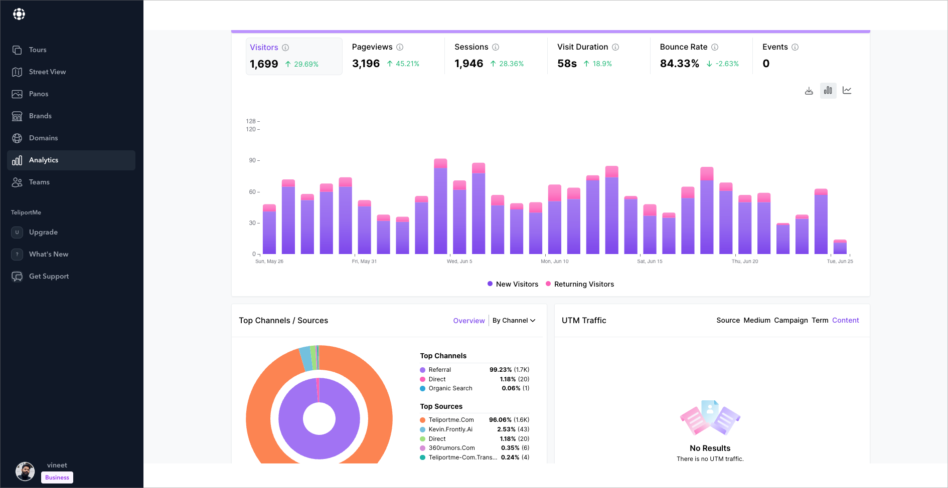
Data Analytics and Reporting in Virtual Tours
Utilizing Data to Improve Virtual Tours and Customer Experiences
Virtual tour software platforms integrate robust data analytics tools that track and interpret user interactions. Heatmaps highlight areas where users spend the most time, revealing which sections of a tour attract the most attention. Session duration metrics provide insight into engagement levels, while drop-off points indicate where users lose interest.
Advanced analytics platforms provide deeper insights by leveraging machine learning algorithms to identify patterns in user behavior. For instance, AI-driven analytics can determine correlations between specific user actions and successful conversions. Businesses apply these insights to refine tour designs, optimize navigation, and enhance visual elements that drive engagement.
Analyzing User Engagement and Behavior to Inform Marketing Strategies
Tracking user behavior within virtual tours generates data that informs marketing decisions. Click-through rates on embedded links, interactions with multimedia elements, and social sharing statistics measure content effectiveness. Segmentation tools break down visitor data by demographics, location, and device usage, enabling targeted marketing strategies.
- Conversion tracking: Monitors how virtual tours contribute to lead generation and sales by mapping user journeys from entry to action.
- A/B testing: Compares different versions of a virtual tour to determine which layout, navigation style, or call-to-action placement yields higher engagement.
- User flow analysis: Identifies the most common navigation paths taken by users, improving layout optimization.
- Engagement metrics: Measures interaction frequency with hotspots, videos, and clickable elements to refine content placement.
Integrating data from virtual tours with CRM systems and marketing automation platforms enhances personalization efforts. Businesses use visitor behavior insights to tailor follow-up emails, retarget advertisements, and refine content strategies for improved customer engagement.
Future Outlook of Virtual Tour Software Market
Evolution of Virtual Tour Technologies
Advancements in artificial intelligence and immersive technologies will push virtual tour software beyond current capabilities. AI-powered automation will streamline virtual tour creation, reducing processing time and minimizing manual input. Enhanced machine learning algorithms will improve image stitching, object recognition, and real-time scene modifications.
Web-based virtual tours will gain higher adoption rates due to improvements in WebXR and browser-based rendering technologies. Cloud computing and edge processing will enable real-time updates, allowing users to interact with dynamic 3D environments without the constraints of high processing power.
5G connectivity will enhance streaming quality, eliminating latency issues in live virtual experiences. Combined with improved compression algorithms, high-resolution panoramic images and 360° videos will become standard, improving visual fidelity and user engagement.
Market Dynamics and Industry Adoption Changes
Real estate, tourism, and education currently dominate the virtual tour market, but new industries are adopting the technology at a growing rate. The global virtual tour software market, valued at approximately $293.8 million in 2023, is projected to reach $947.6 million by 2032, growing at a 13.7% CAGR (source: Market Research Future, 2024).
- Real Estate: AI-driven property analysis and interactive virtual staging tools will optimize agencies' workflows, reducing on-site visits while increasing conversion rates.
- Tourism and Hospitality: Personalized virtual experiences will integrate with travel booking platforms, allowing consumers to explore destinations before making reservations.
- Higher Education: Institutions will expand virtual campus tours, adopting mixed reality environments to enhance student engagement.
- Retail and E-commerce: Virtual showrooms will leverage AR integration, creating comprehensive digital shopping experiences.
- Healthcare: Virtual facility walk-throughs will improve patient familiarity with medical environments, reducing anxiety before procedures.
- Manufacturing and Logistics: Enterprises will adopt VR-based training simulations for improving operational efficiency and safety compliance.
Emerging Business Models and Competitive Strategies
The shift towards subscription-based pricing in SaaS models will dominate new releases, offering flexible scaling for businesses of all sizes. Open-source platforms and API-driven solutions will facilitate hybrid integrations, allowing enterprises to customize virtual tour functionalities.
Strategic mergers and acquisitions will define competition, with tech giants acquiring startups specializing in AI-powered rendering and haptic feedback systems. Companies investing in real-time collaboration and multi-user experiences will gain a competitive edge in sectors emphasizing remote decision-making.
Challenges and Growth Barriers
Despite innovations, certain limitations will persist. Resistance to adoption due to hardware costs and the digital divide will slow implementation in smaller markets. Businesses relying on legacy infrastructure may require substantial investment in compatible devices and software ecosystems.
Data security concerns, particularly in industries handling sensitive consumer information, will push vendors to enhance encryption protocols and compliance with global data protection regulations such as GDPR and CCPA.
Final Considerations
Technological improvements, changing consumer expectations, and industry-specific innovations will define the future of virtual tour software. Companies that prioritize AI integration, cloud-based deployment, and multi-platform accessibility will maintain leadership in the evolving landscape.
Seizing the Opportunities in the Virtual Tour Software Market
Businesses across industries have integrated virtual tour software to enhance customer engagement, streamline marketing, and improve sales conversions. Real estate, tourism, education, and retail benefit from interactive, immersive experiences that provide potential clients with detailed insights before making decisions.
Combining high-quality 360-degree visuals with interactive elements strengthens brand presence while increasing user retention. Companies leveraging these technologies report higher conversion rates, improved customer satisfaction, and reduced operational costs related to in-person visits.
Technology, Marketing, and Customer Engagement in Sync
The virtual tour software market thrives on the intersection of advanced imaging, artificial intelligence, and user-friendly interfaces. Businesses that integrate these tools effectively gain a competitive edge by enhancing customer experiences and streamlining operations. With strong marketing strategies, personalized virtual tours drive engagement, keeping users active and invested.
Real estate firms automate property showcases, e-commerce brands provide detailed product walkthroughs, and educational institutions offer immersive learning experiences. Strategic implementation expands brand reach and improves communication with target audiences.
Accelerate Your Business with Virtual Tour Software
Adopting virtual tour technology ensures businesses remain competitive in an increasingly digital landscape. The demand for interactive, user-driven content continues to rise, making virtual tours a key investment for industries aiming to boost engagement and sales.
Explore leading virtual tour software solutions to enhance customer experiences and increase business efficiency. Stay ahead of the curve by integrating immersive digital technology into your marketing and sales strategies.
]]>Today we are excited to unveil a transformative update to TeliportMe.
- where creativity meets functionality
The Vision Behind "No Boring Virtual Tours"
Today, capturing and maintaining audience attention challenging – and more crucial – than ever. We believe that virtual tours have the potential to be not just informative, but truly captivating experiences that tell your story in a unique and engaging way.
At TeliportMe, we've always envisioned a world where virtual tours are more than just boring digital walkthroughs – they're immersive, interactive storytelling tools that captivate and inform. This update is the culmination of that vision, designed to empower you to create virtual experiences that can truly resonate with your audience. It's about giving you the tools to craft experiences that don't just showcase – they engage, inform, and convert.
And the best part? Despite the power and flexibility of these new features, we strived hard to keep the user experience simple and intuitive. Everything is drag-and-drop, with no need for coding or complex settings. We believe that powerful tools should be accessible to everyone, regardless of technical expertise.
Let's dive into the four key features that make this possible:
Themes:
In today's world, brand consistency is crucial. Your virtual tour should be an extension of your brand, not a generic template.
With our new Themes feature, you have unprecedented control over every visual aspect of your tour. Colors, sizes, shapes, positioning, fonts, icons – all are at your fingertips.
Imagine a real estate agency creating tours that perfectly align with their brand, instantly recognizable and professional. Or a museum crafting a virtual experience that mirrors the ambiance of their physical space.
With Themes, your virtual tour becomes a powerful branding tool, setting you apart while staying true to your brand identity.
Youtube tutorials : https://www.youtube.com/playlist?list=PLS4hRLaA86g2KsMPjn3WsoqkIe1QYpT2e
Smart Bubbles:
Information overload is the enemy of engagement. Your audience craves clean, intuitive interfaces that deliver information on demand.
Our new Smart Bubbles feature transforms how you present information within your tours. Instead of cluttered scenes filled with text tags, buy buttons etc, you can now create clean, immersive environments where curiosity drives discovery.
Combine our Polygon Hotspot with our Smart bubbles and you can have your viewers click on objects of interest to reveal custom information panels, tailored to your needs instantly like a treasure hunt game.
Why is this important ? It allows you to create layered, interactive experiences that keep viewers engaged longer.
A university could use this to showcase campus facilities, revealing detailed information about each building or department upon click. A real estate virtual tour could offer in-depth property details without cluttering the visual experience.
It's about creating a journey of discovery that keeps your audience captivated and coming back for more.
Interactive Menu Bar:
Your virtual tour should be more than just a visual showcase – it should be a comprehensive hub for your audience.
The new menu bar feature transforms your virtual tour from a simple marketing asset into a powerful, standalone, interactive website. This mobile-responsive menu can link to elements within the tour or to external resources, creating a centralized digital experience.
This feature turns your virtual tour into a powerful, multi-functional tool that can drive engagement, provide information, and even facilitate conversions – all within a single, immersive experience.
A restaurant could create a tour that not only showcases its ambiance but also includes menus, reservation systems, and customer reviews – all accessible through the menu bar. A retail store could offer a virtual shopping experience, with the menu bar linking to product categories, checkout pages, and customer support.
Youtube Tutorial : https://www.youtube.com/watch?v=C3ZxnW-7P0o
Fresh Dashboard Design:
Time is valuable, and a streamlined workflow means you can create more impactful tours in less time.
Our dashboard redesign isn't just about looking good (although it does that too!). Built on the modern Tailwind CSS framework, it's about making your creation process smoother and more intuitive. Features and buttons are designed to reducing the learning curve and speeding up your workflow.
Why should you care? Because faster, easier tour creation means you can focus on what really matters – crafting compelling experiences for your audience. Whether you're a seasoned pro or new to virtual tours, you'll find yourself creating stunning, interactive experiences with unprecedented ease.
Here are a few examples of a tour that were created with some of our new features:
- Real Estate : https://teliportme.com/virtualtour/ba6fa15b
- City Treasure Hunt : https://teliportme.com/virtualtour/4ae7208a
- Conference Centre : https://teliportme.com/virtualtour/f83fb542
(These tours were created by Sere Sergiu who actually paid for early access and has been building a great virtual tour business in Romania with all these advanced features.)
Introduction
%20YouTube%20Thumbnail%201280x720%20px%20(20).jpeg)
Whether you're trying to sell a shack in the woods or a city block—the simple strategies below can help you attract more serious buyers.
This guide is designed for busy professionals, so we've included only the essential information you need to survive in the real estate industry. It starts with best practices (ordered from basic to advanced) and concludes with commonly asked questions.

Best Practices
Ordered from Basic to Advanced
1) Manage Your Online Reputation
Clients must not only trust in your knowledge of the market but also in your integrity and commitment to their best interests.
Since your online presence is often the initial point of contact for many potential buyers, ensure that your website (and social media profiles) are polished and professional.
We also recommend actively monitoring reviews and promptly addressing feedback. By presenting yourself authentically and professionally online, you'll make a positive impression on prospective clients and increase the likelihood of building trust and securing successful transactions.

2. Keep Your Online Listings Current
Some realtors (the worst!) lure in potential renters and buyers by leaving unavailable listings on their websites well after they've been scooped up.
This is a terrible strategy for many reasons. First, it makes you look incompetent. It wastes time. It erodes trust. It makes your clients question every listing on your website.
While it may require some extra time to remove listings that have been rented or sold, it makes a huge difference to your clients.

3. Run Targeted Ads
Running ads may require an investment, but it's more likely to pay off since it helps you get in front of your ideal target audience.
Facebook's ad platform lets you pick exactly who sees your ads based on things like where they live, their age, interests, and even if they own a home. This means you can make sure your ads are seen by the right people – those who are most likely to be interested in buying or selling a property.
Furthermore, you'll have options to retarget anyone who has already interacted with your content. This means you can run ads to qualified leads, reminding them about your properties. So, when they're ready to make a move, they'll remember you first.

4. Segment Your Email Groups
If your client is hunting for a commercial space in the heart of downtown, they're not going to be impressed with the one-bedroom apartment you sent to your entire contact list.
By segmenting your email list based on factors like buying stage, location, budget, or property type, you can tailor your messages to specific segments.
This targeted approach ensures that your emails resonate more with recipients, increasing the likelihood of engagement and conversion.

5) Add a Virtual Tour to Your Listing
"WOW—my dream home!" is not a reaction anyone has ever had after seeing a few grainy photos online. Even if you use high-resolution images shot in favorable lighting—it might not be enough to make a potential buyer take notice.
According to the research, virtual tours are far more likely to get viewers to stop scrolling and spend significantly more time looking at your listing. And, ultimately, the more time someone devotes to envisioning themselves in a property, the deeper their emotional attachment becomes.
Since most real estate agents are already aware of this fact, if you're not already using virtual tour technology—we hate to break it to you—but you're behind the times.
If you haven't taken advantage of this tool because you think it's too hard, ask yourself: is it easier to leave money on the table?
In truth, it's actually a very straightforward process. If you can hold a phone and spin around in a circle, you can handle it.
TeliportMe's virtual tour software gives potential buyers a more lifelike experience.
6. Include Drone Photography in Your Listing
Drone photography can make a shack in the middle of the woods look cinematic.
In fact, if you're trying to sell a shack in the middle of the woods, using drone photography might be the best way to showcase the top selling point for potential buyers: the secluded setting.
By providing aerial views and showcasing the property's surroundings from unique angles, drone photography can highlight desirable features such as expansive landscapes, waterfront locations, or prestigious neighborhoods. This elevated perspective can create an impression of luxury and exclusivity, suggesting to potential buyers that the property is worth investing in.

6. Leverage SEO
Visibility can make or break a business. When prospective homebuyers or sellers are scouting for real estate services, it's crucial that your website makes it to the top of the search results.
To ensure your brand gets the attention it deserves, strategically implement keywords that will To achieve this prominence, tapping into the force of SEO is indispensable. By strategically implementing SEO techniques, you can elevate your real estate business's visibility within your local market, ensuring that it captures the attention it deserves. But the journey doesn't end there; fostering a robust online presence through engaging content, responsive design, and active community involvement can further bolster your standing and credibility in the competitive real estate landscape.
Real Estate Marketing: Frequently Asked Questions (FAQ)
What role does social media play in marketing real estate?
While many realtors aren't active on social media, others have gained massive followings. Social media allows realtors to establish their personal brand, showcase listings, connect with interested buyers, and demonstrate their expertise.
How can I build a social media following?
Focus on posting valuable content regularly. Engage with your audience by responding to comments and answering questions.
How do you tailor marketing efforts for different types of properties (e.g., residential vs. commercial)?
For residential properties, marketing emphasizes lifestyle benefits and emotional appeal through high-quality visuals and community-focused messaging, while commercial property marketing emphasizes location, amenities, and financial potential tailored to investors and businesses, using detailed data and industry-specific channels.
How do you adapt marketing strategies for properties with longer sales cycles?
Adapting marketing strategies for properties with longer sales cycles involves implementing a sustained and strategic approach focused on nurturing leads and maintaining engagement over an extended period. This includes deploying targeted email campaigns, drip marketing tactics, and personalized follow-ups to keep prospects informed and interested.
Interested in Learning More?
We recommend exploring these articles:
]]>When developing a construction project for a hotel, real estate or office space, one of the best strategies is to sell your space in advance and have investors and tenants line up to move in as soon as final inspections are completed.
Of course, this can be difficult to do when your marketing materials are flat images of empty and possibly unfinished spaces and a bit dull to look at.
Companies crave a space that not only fits their capacity and workflow but also reflects their brand image in every nook and cranny. They need to know if the lighting is just right, how many workstations can be comfortably accommodated in the area and whether their visitors will be wowed when they set foot in the place.
It's true that traditional images of empty rooms don't make the same impact, but how about giving prospective tenants the opportunity to explore the space in a 360° rendering! This way, they can imagine their future office already furnished and designed to the fullest.
In this article, I'll tell you what 3D renderings are and how to apply them to your pre-sales strategy successfully.
Index:
1. What is a 3D representation of floor plans?
2. Benefits of Launching an Online Pre-Sale for Your Space
2.2 Highlighting the details of the space
2.3 Create your 3D presentation with Teliportme
2.4 Create your unique link to share your space
3. Improve your marketing campaign with 3D Dollhouse
4. Evaluate budget and ROI
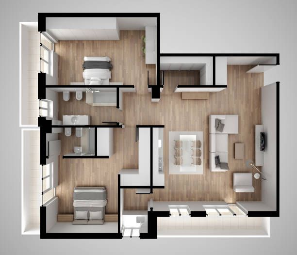
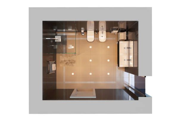
1. What is a 3D representation of floor plans?
A 3D floor plan or 3D dollhouse is a view of a digital architectural space in three dimensions. By viewing a 3D floor plan, you get a more accurate perspective of the size, layout and proportions of a space.
The first and most important benefit of a 3D dollhouse is the ability to visualise your finished commercial property before it is complete and before tenants schedule a live walk-through. The design of the building becomes the guideline for how the rendering is created.
The floor plan, materials and features that will soon be complete will be rendered exactly as they will appear live. The 360° nature of the virtual tour makes it possible for your future tenants or buyers to virtually walk through the space, getting a sense of its size, the flow of the 3D floor plan and even the locations of retail outlets and fixtures.
Here is an example of exactly the experience we can create for your property.
To create these 3D renderings you will need a little imagination and patience and some tools such as Autodesk, Skybox.blockadelabs, Roomle, Floorplanner, Homebyme.
2. Benefits of Launching an Online Pre-Sale for Your Space
Often, buyers of office space or tenants are looking for a space that makes them feel the right way. Real estate, even commercial real estate, is an emotional process. So if it's your first time showing up online remember to be professional, have detailed information about the location and you can demonstrate that your offices create an uplifting workplace that will inspire staff and has the right feel for tenant brands, they are more likely to commit to renting or buying quickly with you.
So the recommendations and advantages for a pre-sale are:
- Show your building before it's ready: This we can call Captivate, if the property is still in the construction or renovation phase, a 360 tour shows what it will become and can close deals before the space is actually ready to be seen.
It can also prepare prospective tenants or buyers for a much quicker in-person tour when the space is finally ready.


- Sell or rent your listings faster and for more: Studies have shown that listings with virtual tours sell 20% faster and for 9% more.
- Save time showing the property: 3D tours can save time by giving you the opportunity to arrange a walk-through without an in-person appointment. In fact, a 360 tour is even easier to self-guide and curious prospective tenants can do their own research, examining every nook and cranny to their satisfaction, without needing to take up their time with a live tour appointment.
- Increase interactivity and connection: A virtual tour also increases each potential commercial tenant's engagement and connection to the property. 360 tours are interactive. The customer can turn, look up, look down and even peek into conference rooms.
So, they can explore the office space at their leisure, invite other decision-makers and simply reload the tour to experience the interactive again.
- Seamless integration: Integrate the immersive tour seamlessly into your website or advertising platforms to ensure easy access to potential tenants. Ensure the tour is mobile-friendly so users can explore your office space on smartphones and tablets, maximising engagement and accessibility.
2.2 Highlighting details of the space
Online pre-sales can greatly accelerate the processes of selling your space. But more importantly, it allows you to assess what aspects to improve in each presentation and how to highlight those details that make the difference. And what better way to achieve this than with innovative tools that you can add to a virtual tour?
That's where virtual floor plans and 3D dollhouse plans come into play. Detailed and informative virtual floor plans show the layout, dimensions and key features of your office space in a way that sparks curiosity and excitement.
Prospective tenants can visualise the possibilities, plan their future workspace and determine how your office fits their needs and what's better with modern software like Teliportme you can add a virtual host, split view, map view and embed links for additional information to the same tour.
2.3 Create your 3D presentation with Teliportme
The crucial moment has arrived, feel the thrill of making an online pre-sale and making big profits - it's impossible to resist running and bringing your project to life! But to stay on top of the excitement, you must get to know one of the most innovative options in the last 10 years: Teliportme.
Here's more than just a simple tip: How to add FLOORPLANS to your virtual tour
2.4 Create a unique link to share your space
Once you have finished creating your 3D representation, it's time to show it to the world. From the platform you are using, in this case, Teliportme, go to the sharing section and customise the way you want to spread your masterpiece.
Make it as unique as you want! From links to share in Whatsapp groups, QR codes or embed links to integrate into your website or property listing. This way, you can integrate an immersive tour on your website and advertising platforms so that potential tenants can explore your office space in an easy and accessible way.


Make sure the tour is mobile-friendly so they can enjoy the full experience on smartphones and tablets, which will maximise engagement and accessibility with your potential clients.
3. Improve your marketing campaign with 3D Dollhouse
Residential and commercial property buyers want an immersive 360° experience. If you plan to incorporate this tool into your marketing campaign, we suggest you consider these valuable tips:
- Enhanced marketing materials: a 360° dollhouse creates beautiful still panoramics and an interactive marketing asset that any curious potential buyer can explore with a few clicks. The floor plan created when the rendering is built is also an excellent way to show the true size and flow of the space from a bird's eye perspective that goes beyond the floor plans provided by the architectural design.
In fact, a rendered floor plan can include rendered furniture such as workstations, conference tables, reception desks and other essentials that will help prospective tenants visualise the value of their space from every angle from the moment they scan the listing of their office space.
- Create a WOW factor: A 360 virtual tour also provides the opportunity to wow office space buyers. It is more impressive and more immersive than simple photographs and gives a sense of what it would be like to actually move around the space.
Your virtual tour can be a customer's first experience with virtual reality (VR) and wandering the virtual corridors of an office can be an enticing pastime while contemplating the benefits of commercial relocation.
4. Evaluate budget and ROI
Finally, a full 3D tour with renderings and floor plans is just a click away! Plus, it's incredibly affordable compared to other immersive marketing options. With a minimum investment of only $333 USD per month, you can bring your properties to life with as many renderings as you want to create.
Regardless of the marketing strategy you are using, keeping an eye on the following factors can help you determine if your campaigns are truly successful for your online pre-sale:
- Time: how long did it take you to create the marketing materials?
- Cost of production: track the total cost of supplies, services and software needed to create the campaign.
- Promotional costs: did you spend anything on promotion? If so, add that to your total costs.
- Page analytics: Use a tracking URL to determine if your content is driving traffic to your product landing page.
- Non-financial returns: Did you get any social media engagement, unexpected traffic increases or other bonuses from your campaign? If so, this can help your brand's engagement level.
Imagine all the total visuals, experiences and wow factor opportunities you can create with a virtual representation of your office buildings - the investment and ROI are self-explanatory!
On the other hand, calculating ROI helps to:
- Establish the success of a business in relation to the expenses derived from it.
Know which product has the highest profitability within a market portfolio.
Estimate the internal rate of investment for future launches.
Cut costs when they exceed the income received.
Predict the success or failure of a commercial operation in the medium and long term.
So why wait? Start sharing your immersive assets with your property listings now and wow your clients before your contractors have finished the finishing touches.
Elevate Your Pre - Sale Strategy
Start an Unlimited Free Trial with TeliportMe Virtual Tour Software
Start Free TrialUnlike static images, virtual tours capture details with unparalleled clarity, giving viewers a more accurate sense of dimension and layout. This level of accuracy fosters trust and confidence in potential buyers, enticing them to explore your real estate listing at their own pace and from any location they desire.
In this article, we provide step-by-step instructions to craft a professional-looking virtual tour. We'll guide you through every stage--from selecting the best equipment for your budget and needs to sharing your tour online.
Step 1: Choose Equipment
To create a virtual tour, you have 3 options for image capture: the P360 app for iOS and Android, a 360 camera, or a DSLR.
The equipment you choose will depend on your budget and priorities. In this section, we'll offer expert recommendations tailored to your needs, whether you're seeking a convenient, budget-friendly option or prioritizing superior image quality.
_YouTube_Thumbnail_1280x720_px_(15)%20(8).jpg)
P360 App
If convenience and speed are top priorities, and you don't want to splurge on a fancy camera, we recommend using the P360 app for capturing 360-degree panoramas. If you've got a relatively new phone, chances are its camera can do the job just fine.
However, it's important to note a key limitation: neither P360 nor any other app can capture a complete spherical panorama. Due to current stitching technology, you won't be able to capture views of the area directly above and below your phone's camera.
_YouTube_Thumbnail_1280x720_px_(15)%20(7).jpg)
360 Camera
360 cameras come with built-in software that makes capturing a full 360-degree view super easy. And don't worry about compatibility—TeliportMe works with every type of 360 camera. Just connect via Bluetooth with the P360 app, and you're good to go.
While 360 cameras deliver exceptional image quality and easily integrate with TeliportMe's virtual tour platform, they do come with a price tag. Expect to pay $400 or more for good model.
If you're looking for a high-quality, dependable model, we recommend the following 360 cameras:
- Best Overall: Insta360 ONE RS
- Best Budget-Friendly: Trisio Lite2
- Best Photo Quality: Ricoh Theta X
For a more in depth look at the features and limitations of these particular cameras, we recommend reading this article.
_YouTube_Thumbnail_1280x720_px_(15)%201%20(1).jpg)
DSLR
If you already have a DSLR, it could be worth considering using it instead of splurging on a 360 camera. With a DSLR, you have the flexibility to swap out lenses, so you might want to explore wide-angle or fisheye options to maximize your camera's potential.
However, we advise against this option for beginners because using a DSLR to create a panoramic image can be tricky. Differences in lighting between shots can pose a challenge, often requiring manual editing of each image to ensure a seamless blend in the final panorama.
If you're planning to use a DSLR, you'll need to rely on your own stitching software. We recommend the following options:
_YouTube_Thumbnail_1280x720_px_(15)%20(10).jpg)
Step 2: Capture
When using the P360 app, you follow these step-by-step instructions:

.jpg)

.jpg)
If you decide to capture your panoramas with a 360 camera or DSLR, you will have to refer to your model's user manual.
Regardless of the method you have chosen, we recommend following these best practices for capturing the best possible images.
1. Position your camera appropriately.
As a general rule, it's recommended to position your camera around 5 feet from the floor, in the center of your space.
However, adjustments may be needed depending on the specific circumstances. For example, when photographing a large room with high ceilings, raising the camera height might be necessary.
The key is to tailor the camera height to suit the unique characteristics of the space you're capturing.
2. Use a tripod.
Even if you have a steady hand, the smallest shake of the camera can result in blurry images with stitching errors. Plus, having the person holding the camera featured in the final result is not ideal.
If you're investing the time and effort to create a virtual tour, it's worth taking the extra step to set up a tripod. Using a tripod ensures stability and consistency throughout your shots, leading to sharp, professional-looking images.
3. Maximize image quality.
If you're a novice, don't feel compelled to overcomplicate this step.
The most effective way to maximize image quality is to maintain a clean camera lens. However, it's important not to accidentally damage your lens in the process. We recommend blowing off any dust or dirt with a blower—not your mouth—which can introduce condensation and saliva.
If the blower doesn't fully clean your lens, you can use a lens brush or a microfiber cloth. Just remember, do not touch the lens with your hands. Even though it might seem insignificant, introducing oil from your hands can damage the lens.
4. Avoid parallax issues.
Parallax errors happen when objects in the foreground and background don't align properly during the stitching process. This misalignment can result in noticeable discrepancies, such as objects appearing distorted or disjointed in the final image.
To avoid this, you will need to pivot around the nodal point and take images that overlap. This will minimize any misalignment and ensure seamless stitching.
Step 3: Edit and Retouch Images (optional)
This step is entirely optional. Unless you're a professional photographer already adept at using editing software, you can likely skip this without any issues.
Some common practices include:
- Adjusting exposure and contrast
- Fine-tuning colors and tones to achieve a more natural or stylized look
- Removing any distracting elements or blemishes
- Applying sharpening or noise reduction
Step 4: Upload to TeliportMe
If you used the P360 app to capture your panoramas, or integrated P360 with your 360 camera via Bluetooth, you've already completed this step.
Create an account with TeliportMe or log in to an existing account.
If you have signed up for an unlimited free trial, your dashboard will look like this:
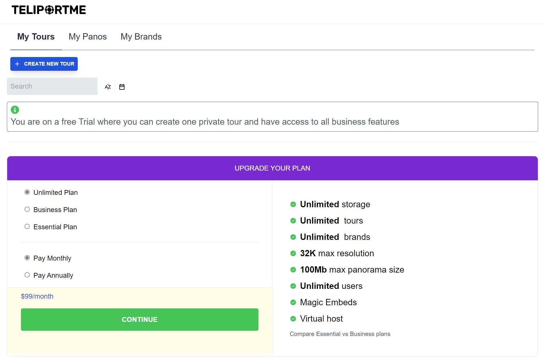
On your dashboard, click "CREATE NEW TOUR" in the upper left-hand portion of your screen. This will open the following window.
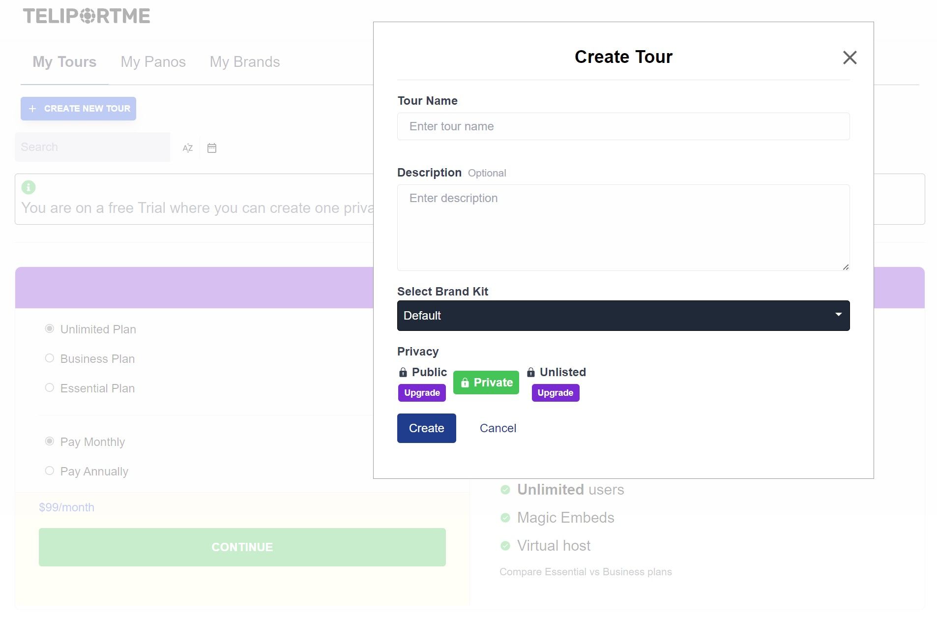
You can add your details, then hit the "Create" button.
Note that free trial users can try all of the business features but cannot publish their tours publicly.

Click "Upload Panorama" to select your image from your computer, or drag and drop your image(s).
Step 5: Add Hotspots and Interactive Elements
A virtual tour truly comes to life when it's interactive.
While navigation hotspots—those clickable points allowing users to move between different areas—are the most commonly used in virtual tours, TeliportMe sets itself apart by offering an array of features not commonly found with other software providers.
Let's take a look at just a few of the features that TeliportMe offers:
- 3D Dollhouse: The 3D dollhouse feature presents the property in a way that resembles a dollhouse—with the walls removed—allowing users to see the entire structure.
- Polygon Content Hubs: Polygon content hubs allow to click around an object of interest to quickly create an informational hub where users can access more information. For example, you might want to highlight a special amenity like a sauna, providing extra information about its features the materials used.
- Magic Embed: The magic embed feature is a powerful tool that enables you to seamlessly incorporate videos directly into your virtual tour. Some of our customers have utilized this feature to make televisions depicted in the panoramas play videos, effectively simulating real-life scenarios within the virtual environment. Others have employed it to conceal personal portraits or sensitive information from public view, maintaining privacy while still showcasing the space.
- HD Green Screen Videos: With this capability, you can incorporate a virtual host who guides users through the space, providing informative commentary or interactive engagement. This feature adds an extra layer of immersion and personalization to the virtual tour experience, allowing users to feel as though they are being personally guided through the space by a knowledgeable host.
By integrating these interactive elements into your virtual tour, you can create a dynamic and engaging experience for potential buyers. Not only will this showcase the property in the best light, but it will also enable viewers to fully explore and interact with the space, ultimately increasing their interest and likelihood of making a purchase.
Step 6: Share
Once you have created your virtual tour, it's time to share it online. Whether you want to embed it on your website, post it on Facebook, or even add your virtual your to MLS, TeliportMe can help you make it happen.
For detailed instructions on how to share your virtual tour, read this article.
If you're still unsure of how to share your virtual tour, we recommend referring to this video tutorial:
Interested in learning more?
We recommend exploring these articles:
]]>There are many different types of digital twins, each tailored to specific industries and purposes. They range from simple virtual replicas to complex digital models capable of optimizing performance in real time.
In this step-by-step guide, we'll walk you through the process of creating a digital twin, breaking down each step with clear instructions. Whether you're in manufacturing, healthcare, or any other industry, you'll find practical tips to tailor your digital twin to your specific needs and goals.
You can expect us to cover the following topics:
- Definition of a digital twin
- Types of digital twins
- Benefits of using digital twin technology
- Building blocks of a digital twin
- Software recommendations
- How to make a digital twin using TeliportMe software
Definition of a Digital Twin
A digital twin is a virtual representation of a physical asset, process, or system. It is created by capturing and integrating data from sensors, cameras, or other sources to create a digital replica that mirrors its physical counterpart.
.jpg)
Types of Digital Twins
Digital twin models can depict anything from individual components to complete systems. While each type serves the same fundamental purpose—virtually modeling real-world objects or systems—they vary significantly in their objectives and scope. The four primary types of digital twins are:
Component Twins
Component twins represent digital versions of specific parts within a system or product, such as gears or screws. Unlike modeling every single part, component twins focus on crucial components, especially those subjected to specific stresses or temperatures. By digitally simulating these parts, designers, and engineers can identify improvements to enhance their performance and integrity under expected conditions.
Asset Twins
Asset twins, also known as product twins, depict digital versions of entire physical products rather than individual components. While they may incorporate multiple component twins, asset twins aim to understand how different parts function together within a single real-world product. For instance, a wind turbine may have an asset twin used for monitoring its performance and detecting potential parts failures caused by regular wear and tear.
System Twins
System twins, or unit twins, are virtual representations of interconnected product systems. While asset twins focus on individual products composed of multiple parts, system twins portray these products as components within a larger system. Understanding the interactions between assets enables improvements in their relationships, leading to enhanced productivity and efficiency.
Process Twins
Process twins are digital depictions of interconnected systems in operation. For instance, while a system twin may simulate a manufacturing line, a process twin could model the entire factory, including employees operating machines on the production floor. This comprehensive representation aids in optimizing workflows and identifying areas for improvement across the entire operational process.
%20YouTube%20Thumbnail%201280x720%20px%20(18).jpeg)
Benefits of Using Digital Twin Technology
1. Improve Efficiency and Reduce Costs
Digital Twins play a critical role in optimizing operations, leading to enhanced efficiency and substantial cost reductions. By creating a virtual representation of a physical system or process, organizations can also identify design flaws and test solutions in a virtual environment, thereby saving time and resources.
2. Mitigate Risk
Digital twins enable companies to foresee potential issues before they escalate by simulating scenarios and monitoring the real-time data of their physical counterparts. This predictive capacity facilitates timely maintenance, helping to avoid downtime and reduce repair costs.
3. Accelerate Innovation
Digital twin technology accelerates innovation by allowing businesses to iterate designs and test products before they are built. It radically improves product lifecycle management by offering insights into each stage of a product's life, from conception to disposal.
4. Predict Trends and Logistical Scenarios
Advanced analytics and machine learning algorithms embedded in digital twins analyze historical patterns and current data to predict future trends. For instance, they can forecast demand patterns, identify potential bottlenecks, or predict the impact of disruptions on the supply chain.
5. Use as Valuable Documentation
Digital twins offer precise virtual replicas of physical assets or systems, providing detailed documentation of their configurations, components, and conditions. This can be used for insurance purposes, for example, to accurately assess the value of assets, evaluate risks, and expedite claims processing.
_YouTube_Thumbnail_1280x720_px_(15)%20(1).jpg)
Building Blocks of a Digital Twin
Although it might seem complicated, in reality, creating a digital twin is often quite simple. Essentially, it boils down to just two key building elements:
1. Data Collection Mechanism
Gathering data is the first step in building a digital twin. Data collection mechanisms can include cameras, IoT sensors, data streams, and even manual input.
2. Software
Advancements in software capabilities have been instrumental in bringing digital twins to fruition. These innovations have enabled the creation of sophisticated modeling and simulation tools, providing the foundation for developing accurate and dynamic digital replicas of physical assets and systems.
Software Recommendations
Developing a state-of-the-art digital twin necessitates the use of sophisticated software that can support complex simulations and data analysis.
The following software has proved successful in their respective industries:
- SmartSignal and Asset Performance Management by GE: provide real-time monitoring of jet engines, wind-farms, off-shore oil rigs, power generation equipment, pumps, compressors, chillers, and more.
- Tecnomatix by Siemens: a comprehensive digital manufacturing software suite designed to streamline and optimize manufacturing processes, offering the two powerful products of Process Simulate and Plant Simulation.
- aPriori Digital Manufacturing Simulation Software: cloud-based platform used by manufacturers to unlock cost, manufacturability, and carbon insights for increased product profitability and sustainability. Geared toward aerospace, defense, automotive, and industrial equipment industries.
- TeliportMe Virtual Tour Software: enables users to create immersive and interactive virtual tours using panoramic images and 360-degree photographs. Best for property documentation.
How to Make a Digital Twin Using TeliportMe Software
TeliportMe is a powerful platform that enables users to create digital twins of real-world environments, such as a room or building. In theory, if you were able to capture enough images, you could build a model of the Earth.
Limitation: While TeliportMe can create accurate 3D models of your space, digitally timestamping individual components, it does not support BIM integration.
Ideal for:
- Property owners seeking comprehensive documentation for insurance purposes
- Real estate agencies using immersive virtual tours to appeal to potential buyers
- Construction project stakeholders requiring remote visualization and progress tracking
- Educational institutions providing virtual campus tours for prospective students
- Business owners interested in marketing their goods/services to prospective customers
- Hotels and tourist destinations offering virtual tours of accommodations and facilities for informed booking decisions
- Organizations preserving cultural heritage sites with virtual access to historic locations
Follow these steps to create your own digital twin:
- Create a free account with TeliportMe: You can't create a phenomenal digital twin without phenomenal software. We recommend beginning with TeliportMe's unlimited free trial. It allows you to try out all of the advanced features without any need to provide credit card information. Once you're satisfied with your digital twin and ready to share it, you can host your digital twin for as little as $19 per month.
- Take pictures of your space: You can use various digital cameras, including your smartphone, to capture all the images necessary to create your digital twin. While utilizing TeliportMe's dedicated app for Android and iOS can simplify this process, note that smartphones are only able to capture a cylindrical view of your space. In contrast, a dedicated 360-degree camera will capture a complete spherical panorama, with full views of the ceiling and floor. (For an in-depth exploration of the best 360-degree cameras on the market, we suggest reading this article.)
- Edit and add interactive elements: To enrich your digital twin, consider integrating videos, audio files, and descriptive text to offer comprehensive information about specific points of interest. This enables you to include details that may be difficult to communicate through visuals alone, enhancing the overall user experience and understanding.
- Share: Using TeliportMe, you have multiple options to share your digital twin: link, embed code, iframe embed code, javascript embed code, or QR code. For enhanced security, you can opt to password-protect your digital twin. (You can find a quick video tutorial on how to share your digital twin here.)
Challenges and Considerations in Adopting Digital Twin Technology
To leverage digital twin technology effectively, you must address several key challenges:
- Overcoming a learning curve: While new technologies can make life easier, some people may resist them.
- Cost and resource constraints: Creating a digital twin requires investment in software and allocation of resources for data collection, potentially posing challenges in budgeting and staffing.
- Scalability: Your project may grow in volume and complexity, requiring periodic updates to your digital twin.
Interested in learning more?
]]>In the construction industry, digital twins have changed the way projects are managed and documented.
But what exactly is a digital twin?
A digital twin is a virtual replica of a construction asset that can be used to document and track the status of a project.
Unlike traditional documentation methods, digital twins capture more detailed information. By connecting the physical and digital worlds, they allow stakeholders to visualize, analyze, and optimize every aspect of a project's lifecycle, from construction to maintenance.
In this article about digital twins, we'll take a look at their various applications, advantages, and how they empower stakeholders to make well-informed decisions.
You can expect us to cover the following topics:
- Benefits of Using Digital Twins for Construction Projects
- Software Recommendations
- 360 Camera Recommendations
- How to Create a Digital Twin
- Challenges and Considerations in Adopting Digital Twin Technology
- ROI Analysis for Construction Companies
- Additional Educational Resources
Benefits of Using Digital Twins for Construction Projects
Here are some key benefits you can expect to gain from incorporating digital twin technology into your construction projects:
- Enhanced Visualization:
Digital twins enable stakeholders to virtually navigate through construction projects, providing a 3-dimensional perspective of the space. This enhances understanding for all involved, even when viewing remotely. - Improved Collaboration:
Traditionally, construction projects involve numerous stakeholders, including architects, engineers, contractors, and clients. Each stakeholder has its own set of data and information, which can lead to miscommunication and delays in decision-making. However, with digital twins, all stakeholders have access to a centralized platform where they can easily access and share data remotely. - Greater Accessibility and Elimination of Safety Risk:
Construction sites are inherently dangerous and pose various risks to stakeholders. By providing an avenue for remote viewing, digital twins facilitate greater accessibility and eliminate potential safety hazards. - Cost and Time Savings:
Digital twins help team members identify potential issues early on, preventing costly mistakes. Simulating and analyzing construction processes also saves time and improves overall project efficiency. - Improved Lifecycle Management:
Digital twins allow for monitoring and managing the entire project lifecycle, ensuring a comprehensive approach to project management and long-term success. - Insurance Documentation: In the case that a natural disaster strikes, you can use your digital twin as proof to substantiate and expedite insurance claims.


Software Recommendations
While Matterport is the biggest name in the space, using Matterport software has some serious drawbacks. Most significantly, customers are required to grant Matterport "non-exclusive, irrevocable, non-transferrable, worldwide, royalty-free right and license to Customer Data." (See Section 9.4 of Matterport's Platform Subscription Agreement)
Eww. We give that policy two thumbs down.👎👎
TeliportMe, on the other hand, is a Luxembourg-based company and is subject to some of the strictest data security regulations in the world. When you use our software, you can rest assured that your data is protected.
We provide a comprehensive array of customizable features for different user needs, and our dedication to customers and innovative practices has earned us the #1 ranking in the industry for customer satisfaction.
It's not just about technology for us – we believe in doing business the right way. We are dedicated to maintaining high ethical standards and never compromising our integrity to make more money. This commitment ensures that when you choose TeliportMe, you're not just getting advanced features; you're also getting a trustworthy and transparent platform that values your satisfaction and operates with honesty and integrity.
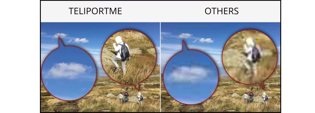
360 Camera Recommendations
If budget and convenience are your top priorities, then using a smartphone to capture 360° images may be your best option. However, it's important to be aware of a significant limitation of smartphones: they cannot capture a spherical panorama. This means you may be missing views of the floor or ceiling.
In order to capture a spherical panorama to create a digital twin, we recommend using a 360 camera. In our expert opinion, these are the best 360 cameras available today:
- Best Overall: Ricoh Theta Z1
- Best Image Quality: Insta360 One RS 1 inch
- Most User-Friendly: Insta360 X3
- Best Budget-Friendly: Trisio Lite2
- Highest Resolution: Xphase Pro X2
For more information on specific features, advantages, and limitations, we recommend reading this article.
.jpg)

How to Create a Digital Twin
Digital twins can be created using a range of technologies, including 3D laser scanners, sensors, cameras, and other Internet-of-things (IoT) devices. While this may sound like a complex process, TeliportMe makes it possible for anyone to create a digital twin, even providing capabilities to create them with a smartphone.
To create a digital twin, there are four main steps:
- Create a Free Account with TeliportMe: You can't create a phenomenal digital twin without phenomenal software. Fortunately, TeliportMe provides a range of options for every need and budget. We recommend beginning with their unlimited free trial, which allows you to try out all of the advanced features without any need to provide credit card information. Once you're satisfied with your digital twin and ready to share it, you can host your digital twin for as little as $19 per month.
- Capture: You can capture a digital twin using a variety of digital cameras, including the smartphone in your pocket. While it's easiest to capture images using TeliportMe's dedicated app for Android and iOS, it's important to note that a smartphone can only capture a cylindrical view of your space. A dedicated 360 camera, on the other hand, will capture a complete spherical panorama. (For a deep dive into the best 360 cameras, we recommend reading this article.)
- Edit and Add Interactive Elements: You can enhance your digital twin by incorporating videos, audio files, and descriptive text to provide detailed information about specific points of interest. This allows you to include information that might be challenging to convey through visuals alone.
- Share: With TeliportMe, you can share your digital twin in different ways: either via link, embed code, iframe embed code, javascript embed code, or QR code. For added security, you may also choose to password-protect your digital twin.
Challenges and Considerations in Adopting Digital Twin Technology
To leverage digital twin technology effectively, construction firms must address several key challenges:
Overcoming a learning curve and resistance to change
While new technologies can make life easier, some people may resist them. In the construction industry, professionals might find it challenging to grasp and use digital twin technology, especially if they're used to traditional methods.
To overcome this resistance, it's essential to provide effective training initiatives.
Cost and resource constraints
To create a digital twin, you need to invest in software and allocate resources for regular updates, which may bring up budget and staffing challenges.
However, it's important to consider the return on investment for each expense. Digital twin technology can efficiently save time and money for construction professionals, especially in the long run.
Scalability
With each passing day, your project will continue to grow—that's the nature of the business. As your project grows, more time may be required to update your digital twin.
While this challenge will continue to compound, it becomes even more critical to update your digital twin as up-to-date information is essential for effective project management.


ROI Analysis for Construction Companies
Construction companies can expect to reap long-term cost benefits with digital twins. Digital twins provide real-time monitoring, allowing professionals to identify and address potential issues before they escalate into costly problems.
Furthermore, digital twins enable remote viewing, streamlining stakeholder collaboration and reducing the need for on-site meetings. This can result in significant cost savings over the lifespan of construction projects.
Construction companies can also improve safety and risk management through digital twins, avoiding costly accidents and legal implications.
Interested in learning more?
]]>A digital twin, also known as a virtual twin, is a digital model designed to accurately reflect a physical object, system, process, place, or even a person, and are used to gain insights into the present and future states of the physical twin.
By bridging the physical and digital worlds, digital twin technology has significantly transformed the way various industries operate. They are useful for a wide range of professionals, including engineers, architects, designers, healthcare professionals, and even real estate marketers.
If you've already recognized the potential value of digital twins and are eager to leverage this innovative technology for streamlining processes, improving decision-making, and fostering innovation, this comprehensive guide will guide you toward a successful implementation.
You can expect us to cover the following topics:
- History and Evolution of Digital Twin Technology
- Key Components of a Digital Twin
- Benefits of Digital Twins
- Challenges and Limitations of Digital Twins
- How to Create a Digital Twin
- Integrating Digital Twins with AR/VR
- Data Management Strategies
- The Importance of Standardization and Interoperability
- Cybersecurity Considerations
- Case Studies
- The Future Outlook of Digital Twin Technology
- A Recap of Key Takeaways and Steps Forward

History and Evolution of Digital Twin Technology
Understanding their origin of digital twins provides valuable insights into their current capabilities and future potential. The concept, once a theoretical ideal, has evolved into a cornerstone of modern industry and technology. This section covers the progressive stages and significant milestones that have shaped the development of digital twin technology.
Key Milestones
- Conceptualization (1970s): After the oxygen tank explosion on Apollo 13 damaged the main engine, NASA used various simulators to understand the failure. They then expanded a physical model of the spacecraft with digital elements, creating the first-ever digital twin. This digital twin continuously collected data, helping experts analyze what led to the accident and plan future actions.
- Experimentation and Development (1990s): In the 1990s, NASA started experimenting with digital twin concepts to create virtual replicas of spacecraft and other space exploration assets like the Mars rovers (Spirit and Opportunity). This enabled engineers to simulate and plan maneuvers on the Martian surface before execution.
- Formally Defined (2002): Dr. Michael Grieves (current Executive Director of the Digital Twin Institute and former NASA consultant) defines the digital twin as consisting of three parts: real space, virtual space, and the link for data flow from real space to virtual space. (You can read more about his work here.)
- Advancement in Sensor Technologies (Mid-2000s): In the mid-2000s, advancements in sensor technologies and data collection methods began to facilitate the integration of relevant data from physical entities into digital twin environments.
- Real-Time Data Development (Late 2000s): During the late 2000s, the integration of real-time data became more sophisticated, ensuring that digital twins could dynamically reflect the current state of their physical counterparts.
- Simulation and Analysis Tools Integration (2010s): In the 2010s, advancements in simulation and analysis tools were integrated into digital twin environments, enhancing the capability to virtually simulate scenarios and optimize processes.
- Interdisciplinary Collaboration (2010s): As digital twin technology expanded, the trend of collaboration among professionals with diverse expertise became increasingly prevalent. This collaborative approach fostered an environment where experts from various fields worked together, leveraging their respective skills to harness the full potential of digital twins.
- Predictive Analytics Implementation (2010s): In the 2010s, the implementation of predictive analytics algorithms became more prevalent, allowing digital twins to anticipate future states and potential issues based on historical and real-time data.
- User Interface and Accessibility (2010s): Throughout the 2010s, efforts were made to improve user interfaces and accessibility, making it easier for professionals from different fields to interact with and extract insights from digital twins.
- Integration with AI (Ongoing): Digital twins are becoming more integrated with AI, improving its ability to predict future performance, optimize operations, and drive innovation across an array of fields.
These dates provide a general overview, and it's important to note that digital twin technology is always changing, with new advancements continuously influencing its direction.

Key Components of a Digital Twin
Digital twins are composed of the following three elements:
- real entity
- virtual representation
- data link that connects the two (digital thread)
.jpg)
Beyond these fundamental elements, digital twins may also have the following components that play a role in ensuring the digital twin accurately reflects its physical counterpart.
Sensors
Sensors serve as the sensory organs of digital twins, capturing real-time data related to performance, environment, and utilization. This network of interconnected sensors ensures the digital twin offers a live reflection of the physical object, allowing for prompt maintenance, fine-tuning, and the anticipation of potential issues before they arise.
Software
Software is critical to the operation of a digital twin. It involves the synchronization of various applications and modeling tools that power the digital twin, allowing it to simulate, predict, and optimize the performance of its physical counterpart. This integration enables intricate virtual representations that can evolve, learn, and provide value across multiple stages of the asset's lifespan.
Internet of Things (IoT)
The Internet of Things (IoT) is fundamental to digital twin technology. IoT devices act as sensory input mechanisms, gathering real-time data from various sources, including machines, environmental sensors, and even entire factories. This network of connected devices provides a continuous stream of information that feeds digital twins, allowing them to mirror the physical world accurately.
AI and ML
Intelligence is the hallmark of any advanced system. Artificial Intelligence (AI) and Machine Learning (ML) imbue digital twins with the capability to analyze data, make predictions, and learn from outcomes to enhance performance. AI algorithms can detect patterns and anomalies, while ML models evolve through iterative training, improving the digital twin's predictive accuracy and operational efficiency.
Together, these components form the robust architecture of a digital twin, allowing for a versatile and powerful tool that drives innovation and efficiency in various industries.


Benefits of Digital Twins
1. Improve Efficiency and Reduce Costs
Digital Twins play a critical role in optimizing operations, leading to enhanced efficiency and substantial cost reductions. By creating a virtual representation of a physical system or process, organizations can also identify design flaws and test solutions in a virtual environment, thereby saving time and resources.
2. Mitigate Risk
Digital twins enable companies to foresee potential issues before they escalate by simulating scenarios and monitoring the real-time data of their physical counterparts. This predictive capacity facilitates timely maintenance, helping to avoid downtime and reduce repair costs.
3. Accelerate Innovation
Digital twin technology accelerates innovation by allowing businesses to iterate designs and test products before they are built. It radically improves product lifecycle management by offering insights into each stage of a product's life, from conception to disposal.
4. Predict Trends and Logistical Scenarios
Advanced analytics and machine learning algorithms embedded in digital twins analyze historical patterns and current data to predict future trends. For instance, they can forecast demand patterns, identify potential bottlenecks, or predict the impact of disruptions on the supply chain.


Challenges and Limitations of Digital Twins
As with any transformative technology, the implementation and operation of digital twins come with their own set of challenges and limitations. Businesses and organizations looking to leverage digital twins must be aware of these hurdles to effectively plan and execute their digital twin strategies.
1. Addressing Technical and Operational Issues
The technical complexities of creating a digital twin are non-trivial. Ensuring accurate real-time data synchronization, integrating disparate systems, and maintaining high-performance computing environments demand a robust IT infrastructure. Operational challenges include the need for specialized expertise to design, develop, and manage digital twins, as well as issues related to maintenance.
2. Bridging the Gap Between Expectations and Reality
It is vital to set realistic expectations when deploying digital twins. The promise of comprehensive optimization and predictive analytics may fall short due to data quality issues, incomplete models, or unexpected variables in the physical system. Bridging the gap between expectations and reality requires a clear understanding of the technology's capabilities and limitations.
3. Navigating the Complexity of Implementation
Implementing a digital twin can be a complex process involving multiple stakeholders and systems. The challenges include not only the technical aspects but also organizational hurdles such as resistance to change, misalignment between departments, and ensuring regulatory compliance. Developing a streamlined implementation strategy is crucial to minimize disruptions and realize the full benefits of digital twins.
- Technical Integration: Seamlessly integrating digital twins with existing systems can be difficult, as it often requires bespoke solutions and continuous adaptation.
- Data Privacy and Security: Protecting sensitive information and ensuring robust cybersecurity measures in a digital twin environment is a significant concern, given the potential for data breaches.
- Interoperability: Digital twins must be able to communicate with other systems and technologies, which requires a set of shared standards and protocols that may not be fully developed or adopted industry-wide.
- Cost: The initial investment for developing and implementing a digital twin can be high, making it necessary to carefully evaluate the return on investment and long-term benefits.
4. Conquering Scale-Up Struggles
Coordinating and synchronizing multiple digital twins within a larger system pose complexities in data orchestration and ensuring seamless interoperability. This underscores the importance of addressing scalability challenges not only at the individual digital twin level but also in the context of a comprehensive and interconnected system.
It is important to set realistic expectations when deploying digital twins within a larger framework to maximize their effectiveness across complex organizational and technological landscapes.


How to Create a Digital Twin
While methods will vary based on the use case, this segment provides a general roadmap for those looking to create a digital twin.
Phase 1: Assessing Organizational Readiness
Before you can begin implementing digital twin technology, it is vital to evaluate your organization's current state.
Consider:
- Are your systems compatible with a digital twin platform?
- Is your data structured in a way that can be mirrored virtually
- How mature is your existing infrastructure? This may include hardware and software assets, data management, and process integration.
Phase 2: Build a Skilled Team to Manage Twin Development and Monitoring
Incorporating digital twins into your business processes demands a blend of cross-disciplinary skills. Look to recruit or train professionals who can navigate the complex interplay of physical and virtual systems.
We recommend assembling a team with expertise in areas such as:
- IoT
- AI
- Data analytics
- Domain-specific knowledge
Phase 3: Develop a Roadmap for Integration and Scalability
A structured roadmap is key when it comes to integrating digital twins into your organizational ecosystem. Your roadmap will rely on the expertise and capacity of your team.
We recommend:
- Starting with small-scale pilot projects which can provide valuable insights and pave the way for broader functional applications
- Creating a phased approach to minimize disruption
- Define key milestones and deliverables to ensure progress
- Identify pilot projects to validate concepts and gauge ROI
- Decide on benchmarks to measure the success of your digital twin implementations
- Plan for scalability to adapt to evolving business needs and technological advancements


Software Recommendations
Developing a state-of-the-art digital twin necessitates the use of sophisticated software that can support complex simulations and data analysis.
The following software has proved successful in their respective industries:
- SmartSignal and Asset Performance Management by GE: provide real-time monitoring of jet engines, wind-farms, off-shore oil rigs, power generation equipment, pumps, compressors, chillers, and more.
- Tecnomatix by Siemens: a comprehensive digital manufacturing software suite designed to streamline and optimize manufacturing processes, offering the two powerful products of Process Simulate and Plant Simulation.
- aPriori Digital Manufacturing Simulation Software: cloud-based platform used by manufacturers to unlock cost, manufacturability, and carbon insights for increased product profitability and sustainability. Geared toward aerospace, defense, automotive, and industrial equipment industries.
- TeliportMe Virtual Tour Software: enables users to create immersive and interactive virtual tours using panoramic images and 360-degree photographs. Best for property documentation.
Applications of TeliportMe's virtual tour software range from insurance documentation to digital marketing, providing a versatile solution for various industries.
Data Management Considerations
The concept of a digital twin is incomplete without a robust data management strategy. Data is the lifeline that fuels the capabilities of a digital twin, providing insights and predictive analytics that empower decision-makers. In this section, we delve into the essential aspects of Data Management in Digital Twins, focusing on data quality, security, and efficient storage and access.
Data Quality and Consistency
Inaccurate or inconsistent data can lead to erroneous conclusions, potentially compromising the digital twin's effectiveness. Ensuring precise and reliable data involves:
- Implementing stringent data validation processes to verify data accuracy.
- Utilizing advanced algorithms to cleanse and normalize datasets.
- Establishing rigorous protocols for data entry and collection.
- Continuous monitoring and refining of data quality metrics.
Efficient Data Storage
The aim is to manage the volume, velocity, and variety of data generated. Effective strategies include:
- Leveraging cloud services for scalable and flexible data storage solutions.
- Utilizing state-of-the-art database management systems for quick data retrieval.
- Employing data warehousing techniques to organize and store large datasets.
- Ensuring real-time data access to keep the digital twin up-to-date with its physical counterpart.
Extrapolating Insights
With the vast amounts of data collected from IoT devices, Big Data analytics become paramount in driving actionable insights. Some strategies include:
- Implement advanced analytics and machine learning algorithms.
- Develop data visualization tools for clearer interpretation.
- Utilize predictive modeling to anticipate future trends.
- Foster collaboration between data scientists and domain experts for comprehensive insights.
Data Security and Privacy
Data security and privacy must be treated with the highest priority. Sensitive information must be safeguarded against unauthorized access and cyber threats. Key practices to enhance data security and privacy include:
- Encryption of data in transit and at rest to protect against breaches.
- Adoption of robust authentication mechanisms to ensure data integrity.
- Regular audits to identify and rectify potential security vulnerabilities.
- Compliance with global data protection regulations to preserve user privacy.

The Importance of Standardization and Interoperability
A critical aspect that often determines the success and scalability of virtual replicas is the ability to maintain standardization and interoperability. This section explores why setting universal standards is crucial and how industry-wide efforts are paving the way for interoperability.
Importance of Universal Standards
Universal standards in digital twin technologies serve as the backbone for creating robust and interoperable systems. Harmonized standards ensure that different digital twins can communicate and work together effectively, fostering an ecosystem where data and insights can be shared across platforms and industries. This not only enhances the value of digital twins but also contributes to the reduction of integration costs and complexities.
Efforts Toward Interoperability Among Diverse Systems
Interoperability is the key to unlocking the full potential of digital twins. It allows for the seamless exchange of information between various digital twins, even when they are developed by different organizations or for different purposes. This synergy is crucial for large-scale projects, such as smart city initiatives or integrated healthcare systems, where multiple digital twins must operate in concert.
The Role of Consortia and Industry Groups
Recognizing the need for a unified approach, consortia and industry groups have emerged as major players in the drive toward standardization and interoperability. These organizations work collaboratively to devise guidelines, frameworks, and protocols that facilitate the widespread adoption and integration of digital twin technologies. Through these efforts, they aim to establish a common language and shared best practices that underpin the advancement of digital twin ecosystems worldwide.
- Development of industry-specific standards and models
- Collaborative projects between companies and research institutions
- Global initiatives that define data exchange protocols
By addressing these aspects, the industry can ensure that digital twins will serve as a driving force in the era of digital transformation.
Case Studies:
Digital twins have proven their mettle across various industries, highlighted by these case studies:
- Aerospace: NASA's Digital Twins on Mars
- Manufacturing: General Electric’s Gas Turbine Power Plant
- Healthcare: Mayo Clinic’s Patient-Specific Digital Twins
- Energy: Siemens’ Virtual Power Plant
- Construction: Cityzenith’s Digital Twin Platform
- Transportation: Singapore Land Transport Authority's Digital Twin for Intelligent Transportation Systems
- Retail: Walmart’s Digital Twin for Supply Chain Optimization
In each instance, the digital twin served as a robust tool for pre-empting real-world challenges, heralding a new era of predictive analysis and strategic foresight.
Let's look at these cases in further detail:
Aerospace: NASA's Digital Twins on Mars
Perseverance, the Mars rover on a mission to explore the Jezero crater, was launched on July 30, 2020, and successfully landed on Mars on February 18, 2021. As one of NASA's most advanced rovers at the time, it marked a significant step in space exploration. The entire landing process, despite being a complex design involving intricate technology like the sky crane, went off without a hitch.
Digital twin technology played a crucial role in making this mission a success. In the early stages of Perseverance's development, NASA extensively used detailed virtual models to anticipate and plan for the challenges the rover would face on Mars. The digital twin simulations also included the sky crane technology, ensuring a safe and flawless landing on the Martian surface.
To further enhance the rover's capabilities, NASA employed MapleSim by Maplesoft for hardware-in-the-loop simulations. This approach allowed them to simulate specific hardware components alongside digital twins, ensuring a comprehensive understanding of the rover's functions. Additionally, a research team from McGill University and Vortex simulated how the rover's wheels would interact with soft patches on Mars, contributing valuable insights.

.jpg)
Manufacturing: General Electric’s Gas Turbine Power Plant
General Electric’s Gas Turbine Power Plant in Bouchain, France, recently set an efficiency record by turning 62% of its fuel's energy into electricity. To achieve this result, a digital twin system gathers real-time data from sensors installed in the turbines, analyses it, and offers suggestions for optimal performance.
In comparison to older plants with around 3,000 sensors, newer ones like Bouchain have 5,000 to 6,000 sensors which give the plant a constant MRI. This digitization not only detects tiny changes that might signal a need for maintenance but also significantly reduces the chance of unexpected or risky surprises.
Beyond just the turbine, this digital approach extends to the entire power plant, guiding operations through analysis, data, and personalized solutions.


Healthcare: Mayo Clinic’s Patient-Specific Digital Twins
The Mayo Clinic, a renowned healthcare provider, has leveraged digital twin technology to create patient-specific models for improved diagnostics and treatment. By integrating data from various sources such as medical imaging, genetic information, and wearable devices, the Mayo Clinic develops personalized digital twins of patients.
These digital twins simulate the patient’s physiology, enabling physicians to gain a deeper understanding of their condition and design targeted treatment plans. By analyzing the digital twin, doctors can explore different treatment options, predict the effectiveness of interventions, and optimize patient outcomes.
This approach has been particularly effective in areas like cardiac care, where the digital twin helps in planning complex surgeries and predicting the impact of interventions on individual patients.


Construction: Cityzenith’s Digital Twin Platform
A full digital twin platform called SmartWorldPro has been created by Cityzenith, a technology business that specializes in urban planning and development. The platform builds digital twins of cities using data from a variety of sources, including 3D city models, BIM (Building Information Modelling) data, and IoT devices.
The digital twin enables developers and city planners to simulate various development scenarios, optimize resource allocation, visualize complex urban settings, and analyze various aspects of infrastructure.
Additionally, it promotes stakeholder participation, empowering them to speak and act with clarity. Urban planning initiatives all over the world have benefited greatly from the application of Cityzenith’s digital twin platform, making cities more resilient, sustainable, and citizen-focused.


Transportation: Digital Twin for Singapore Land Transport Authority
The adoption of digital twin technology by the transport sector aims to increase the effectiveness and security of transport networks. One such instance is the digital twin of the complete transport system, including the roads, trains, and bus services, that the Singapore Land Transport Authority (LTA) has put in place. To give a complete picture of the transportation ecosystem, the digital twin incorporates real-time data from traffic sensors, fare collection systems, and other sources.
The LTA’s digital twin offers real-time traffic monitoring, enabling authorities to control congestion, optimize traffic flow, and increase overall transportation effectiveness. The digital twin aids in the planning and execution of transport infrastructure enhancements, such as the construction of new roads or public transit lines, by modeling various scenarios.
Additionally, it supports predictive analytics for incident management, enabling early issue discovery and effective interruption response.


Retail: Walmart’s Digital Twin for Supply Chain Optimization
To improve its supply chain processes, Walmart, a global retail organisation, deployed a digital twin solution. To simulate and analyse the complete supply chain network, the digital twin integrates real-time data from numerous sources, such as sales data, inventory levels, and weather forecasts.
Walmart can correctly estimate demand, optimise inventory levels, and enhance logistics and distribution procedures by using the digital twin. Additionally, the digital twin enables simulations and scenario planning to locate possible bottlenecks and enhance the flow of commodities. Customer satisfaction has increased as a result of this application, which has improved inventory management and decreased waste.


Integrating Digital Twins with AR/VR
Integrating digital twin technology with augmented reality (AR) and virtual reality (VR) enhances visualization and provides innovative ways for training and prototyping.
Enhancing Visualization and Interaction with Models
By overlaying digital information onto the physical realm (AR) or creating a fully immersive simulation environment (VR), engineers and stakeholders can interact with their digital twins in a more intuitive and meaningful way. This leads to better understanding of the data, quicker decision-making processes, and a more holistic view of the operational aspects of the twin.
Training and Prototyping Using AR/VR
Trainees can practice operations on virtual models that react in real-time, reducing the risks and costs associated with hands-on training. With regard to prototyping, designers and engineers can test and iterate their models in a virtual environment before any physical prototype is built, saving time and resources while accelerating innovation.
Future Outlook of Digital Twin Integration with AR/VR
The future of digital twins is poised to be deeply intertwined with immersive technologies. As the resolution of VR and AR continues to increase and as the hardware becomes more accessible, the line between physical and digital will blur. This promises a new era where digital twin immersion becomes a staple across industries, providing an unparalleled level of detail and interactivity that will drive the next wave of digital transformation.
- Analyzing complex systems through a more interactive lens
- Reducing gaps in understanding by providing a tangible reference through AR overlays
- Advancing remote collaboration through shared VR environments

Cybersecurity Considerations
As the digital and physical worlds merge closer, securing digital twin data becomes a paramount concern. The interconnectedness poses risks of unauthorized access, manipulation, or exploitation of sensitive information, emphasizing the need for robust cybersecurity measures to safeguard the integrity, confidentiality, and privacy of digital twin data.
As a result, it's critical to understand and implement rigorous cybersecurity measures to protect sensitive data and the systems they mirror and manage.
We suggest the following practices to safeguard your data:
1. Secure Data Across Lifecycle Phases
Data is the lifeblood of digital twins, accompanying assets from inception to retirement. Each stage of the digital twin's lifecycle poses potential vulnerabilities that must be addressed:
- Creation: During this phase, ensuring that the initial data is accurate and comes from reliable sources is crucial for the twin's effectiveness and security.
- Operation: Real-time data streams require encryption and vigilant monitoring to avoid breaches or tampering.
- Maintenance: Regular updates and patches fortify digital twins against emerging threats.
- Decommissioning: Properly disposing of data in the twin is just as important, preventing unauthorized access to historical data.
2. Analyze Risk
A methodical approach to identifying and mitigating potential threats, threat modeling, is vital in the lifecycle of a digital twin. By understanding the various ways a digital twin can be compromised, organizations can implement tailored defenses. This anticipatory measure involves:
- Analyzing the attack surfa ce of the digital twin environment.
- Identifying potential threat agents and the potential impact of their actions.
- Developing a priority list of risks to address based on their severity and likelihood.
3. Establish Robust Security Practices
Robust security tactics are non-negotiable when it comes to digital twin implementations. To safeguard these complex systems, consider the following:
- Multi-Factor Authentication (MFA): Requiring more than one method of authentication enhances access security.
- Encryption: Protecting data in transit and at rest ensures that even if intercepted, the information remains unreadable.
- Segmentation: Limit potential damage by compartmentalizing networks and systems.
- Zero Trust Architecture: Never assume security within the network; instead, verify every access request as if it originates from an open network.
- Continuous Monitoring: Implement real-time security monitoring to detect and respond to threats swiftly.
- Regular Audits: Conduct security audits to uncover any potential weaknesses and ensure compliance with industry standards.


Future Predictions for Digital Twin Technology
Digital twin technology is on the cusp of a transformative journey, poised to redefine how industries operate and innovate. As we peer into the future, several key predictions emerge
- Increased Adoption Across Industries: Digital twin technology is likely to experience widespread adoption across various industries beyond its current applications in manufacturing, healthcare, and energy. Sectors such as logistics, construction, and smart cities are expected to embrace digital twins to enhance efficiency, decision-making, and overall operations.
- Advancements in AI Integration: The integration of artificial intelligence (AI) with digital twin technology is anticipated to grow, enabling more sophisticated data analysis and predictive capabilities. AI algorithms will play a crucial role in extracting actionable insights from the vast amount of data generated by digital twins, further enhancing their value.
- IoT Integration for Real-time Monitoring: The Internet of Things (IoT) will play a more integral role in digital twin ecosystems, enabling real-time monitoring and control of physical assets. This integration will enhance the accuracy and immediacy of data, providing a more dynamic and responsive digital representation of the physical world.
- Expansion into Edge Computing: As edge computing capabilities evolve, digital twin processing is likely to shift towards the edge of networks. This move will reduce latency, enhance real-time decision-making, and enable more efficient use of resources, especially in scenarios where immediate response is critical.
- Standardization and Interoperability: The development of industry standards and increased interoperability between different digital twin platforms is expected. This will facilitate seamless collaboration, data sharing, and integration across various systems and domains, fostering a more connected and efficient ecosystem.
- Digital Twins in Healthcare: The healthcare industry is poised to see increased adoption of digital twins for personalized medicine, patient monitoring, and simulation of medical procedures. This technology could revolutionize healthcare practices by providing more accurate and individualized insights.
- Enhanced Cybersecurity Measures: Recognizing the increasing importance of securing digital twin data, there will be a concerted effort to implement robust cybersecurity measures. This will include encryption, access controls, and other security protocols to protect sensitive information associated with digital twins.
- Human-Machine Collaboration: Future digital twins may facilitate more seamless collaboration between humans and machines. This could involve advanced augmented reality interfaces, enabling workers to interact with and manipulate digital twins in real-time for tasks ranging from maintenance to design.
- Lifecycle Integration: Digital twins are likely to become more integral throughout the lifecycle of products, assets, or systems. From design and development to operation and maintenance, a continuous and evolving digital representation will provide valuable insights and support decision-making at every stage.
- Environmental Sustainability: Digital twins may play a key role in promoting environmental sustainability by optimizing resource usage, energy efficiency, and waste reduction. Industries and cities may leverage digital twins to model and implement eco-friendly practices and strategies.

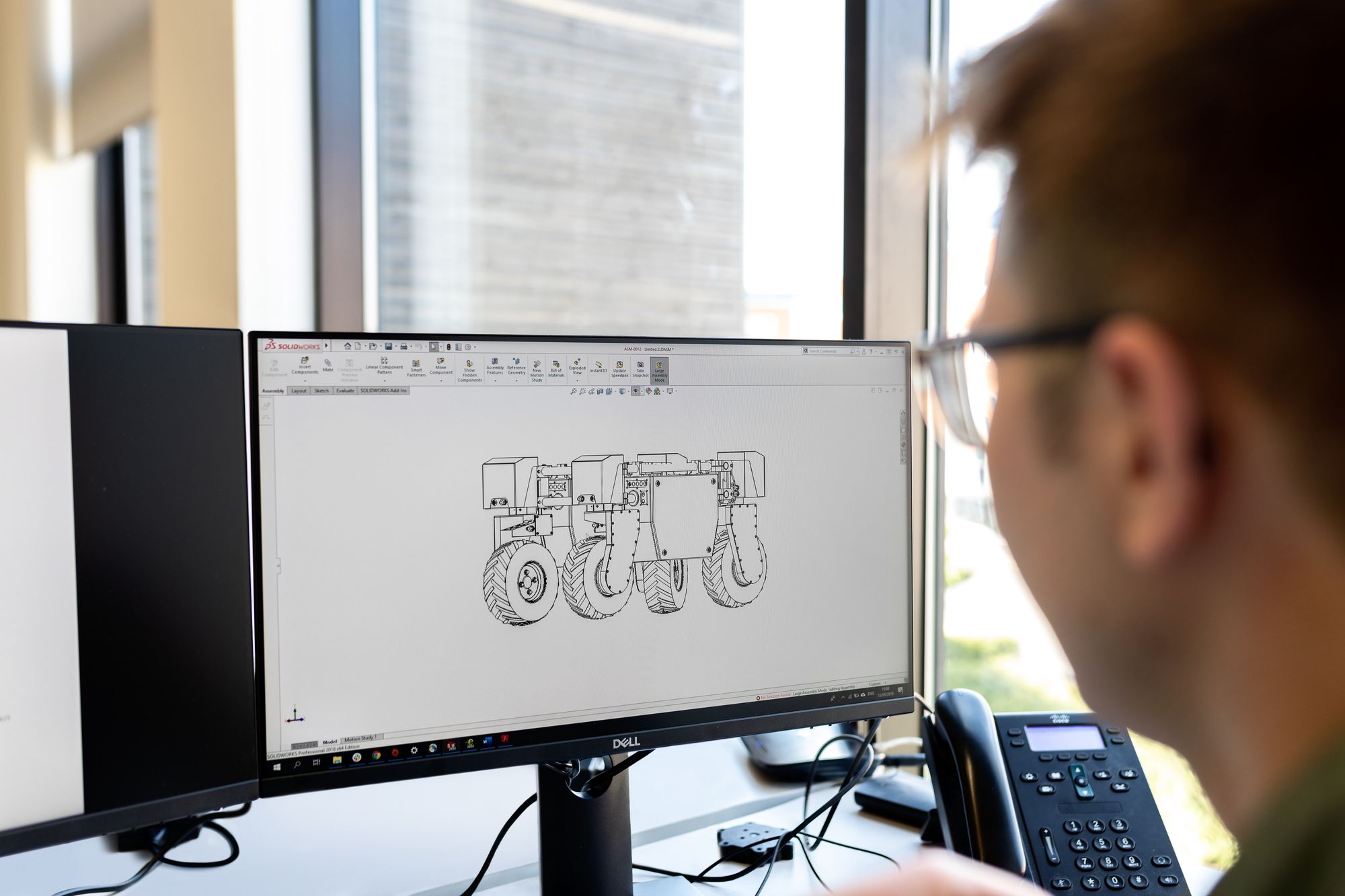
Key Takeaways and Steps Forward
- Digital twins optimize processes, streamline operations, and improve overall efficiency across various industries
- By simulating scenarios and analyzing data, digital twins empower better decision-making, particularly in complex systems
- Digital twins have transformative potential across sectors, contributing to advancements in technology, sustainability, and innovation.
- In taking steps forward, emphasis must be placed on overcoming challenges related to scalability, integration, and standardization.
- As these virtual constructs become even more sophisticated and integral to our digital infrastructure, the focus must also be on nurturing the skills and knowledge base required to leverage their full potential.
For real estate marketing, its advantageous to use 360 cameras because they give potential buyers a more accurate view of a space.
However, not all 360 cameras are created equal. This article highlights the best 360 cameras available today, discussing both their advantages and limitations.
You can expect us to cover the following topics:
- The 5 Best 360 Cameras for Real Estate Marketing
- How to Choose the Best 360 Camera
- Advantages of Using a 360 Camera for Real Estate Marketing
- Cost/Benefit Analysis of Investing in 360 Cameras for Real Estate Marketing
- Educational Resources for Real Estate Marketing with 360 Images
- Privacy and Legal Considerations
- Online Communities for Real Estate Marketers
The 5 Best 360 Cameras for Real Estate Marketing
#1 Best Overall: Ricoh Theta Z1
- Key Features: High-resolution imaging, dual lens system, advanced image stabilization, Zillow integration
- Image Quality: Excellent image quality with sharp details and vibrant colors
- Ease of Use: User-friendly interface and intuitive controls
- Compatibility: Compatible with popular virtual tour software
- Strengths: Impressive image quality, reliable performance
- Potential Drawbacks: Higher price point compared to other cameras
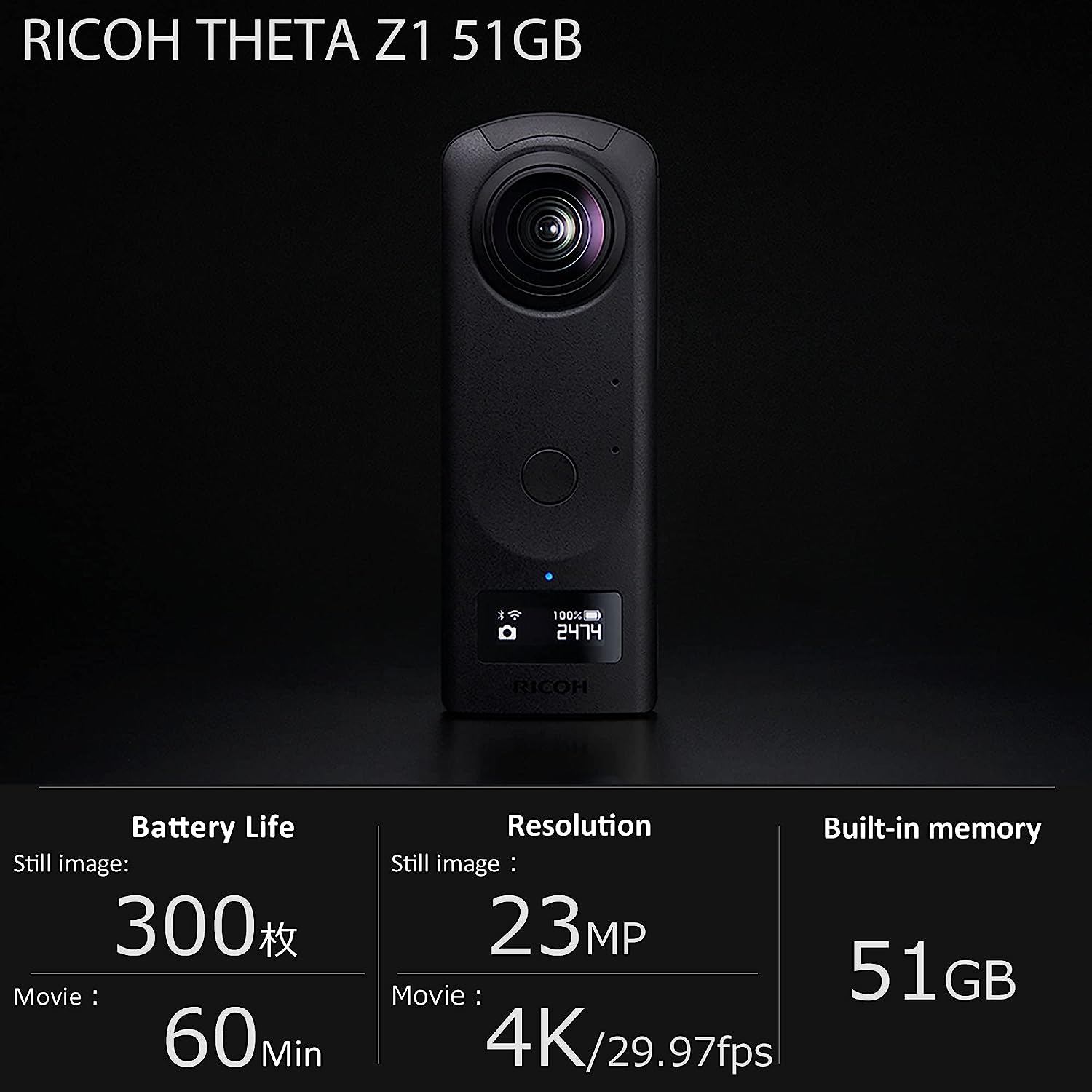
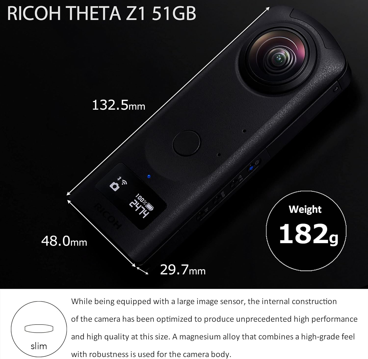
Best Image Quality: Insta360 One RS 1 inch
- Key Features: Large 1" sensor, interchangeable lens system, advanced HDR
- Image Quality: Exceptional image quality with great dynamic range
- Ease of Use: Simple and straightforward operation
- Compatibility: Works well with various virtual tour software
- Strengths: High-quality images, versatility with interchangeable lenses
- Potential Drawbacks: Limited shooting modes compared to other cameras
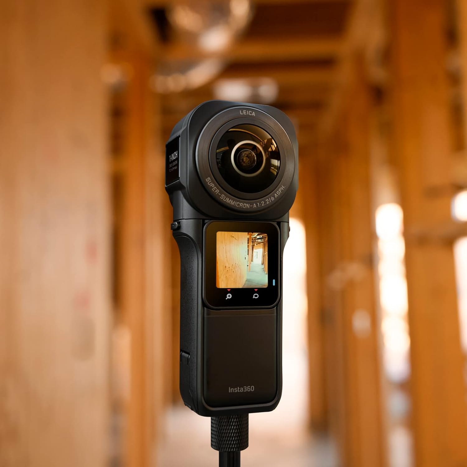
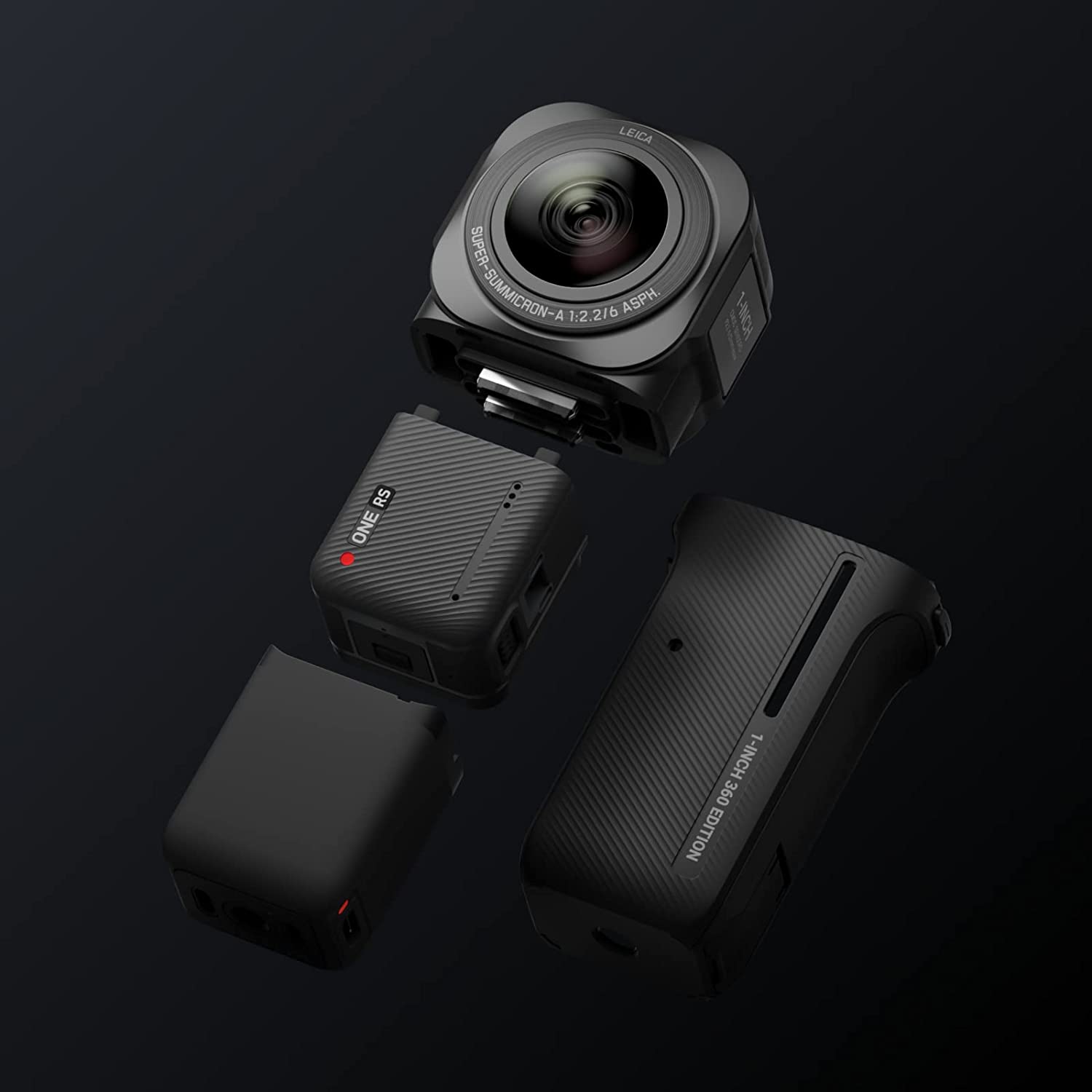
Most User-Friendly: Insta360 X3
- Key Features: Compact/portable, advanced stitching technology, built-in stabilization, active HDR, AI-powered image editing, waterproof up to 33'
- Image Quality: Good image quality with decent level of detail
- Ease of Use: Easy to operate, ideal for beginners
- Compatibility: Compatible with most virtual tour software
- Strengths: Portability, reliable performance, video
- Potential Drawbacks: Lower image resolution compared to other cameras
.jpg)
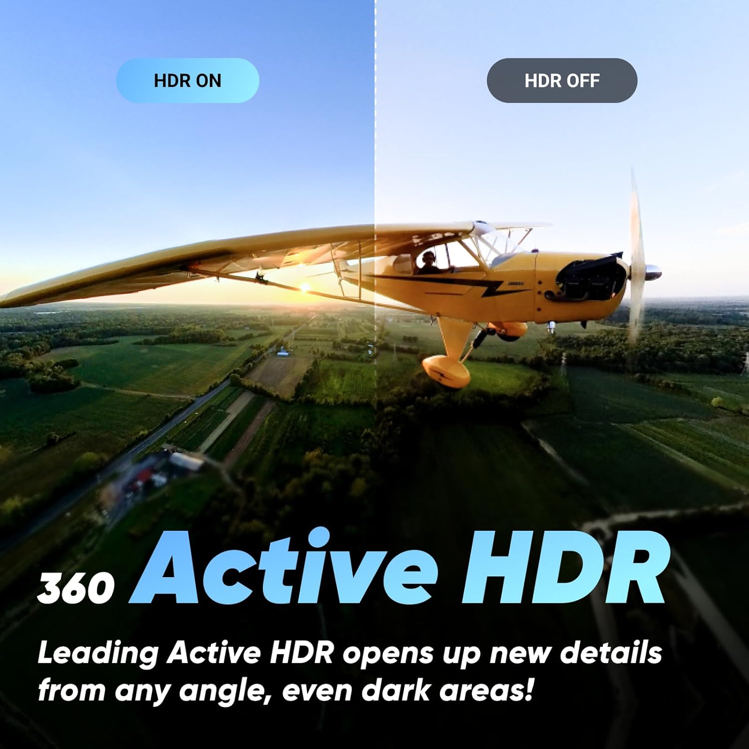
Best Budget-Friendly: Trisio Lite2
- Key Features: Affordable price, lightweight design, user-friendly interface
- Image Quality: Average image quality with moderate details
- Ease of Use: Simple and intuitive controls
- Compatibility: Works well with popular virtual tour software
- Strengths: Budget-friendly option, easy to carry around
- Potential Drawbacks: Limited advanced features and lower image quality
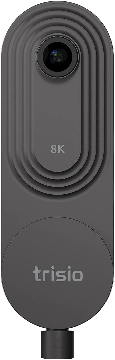
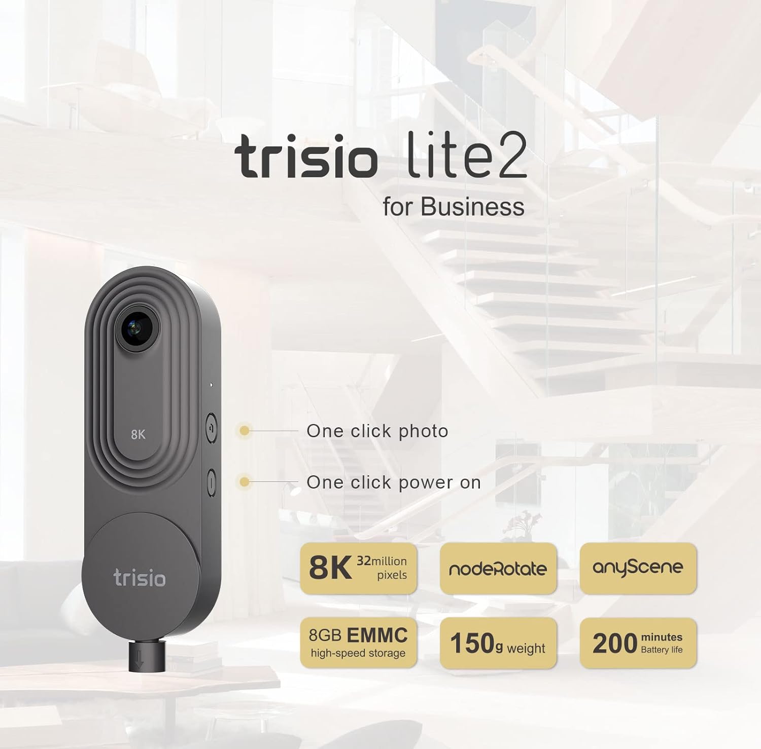
Highest Resolution: Xphase Pro X2
- Key Features: High-resolution imaging, advanced stabilization, time-lapse functionality, Wi-Fi capable
- Image Quality: Excellent image quality with vivid colors
- Ease of Use: User-friendly interface with customizable settings
- Compatibility: Compatible with various virtual tour software
- Strengths: Superior image quality, versatile shooting options
- Potential Drawbacks: Higher price point, slightly larger design
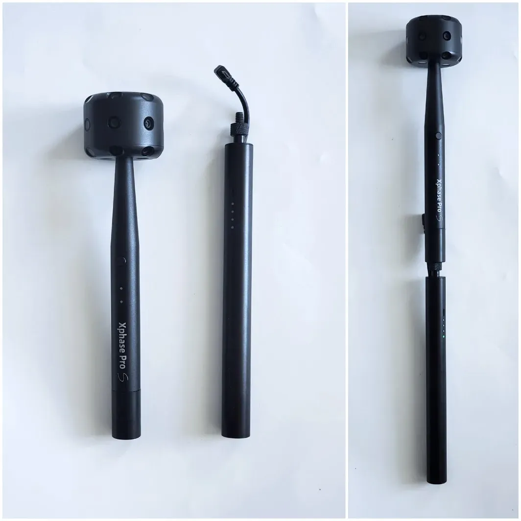
How to Choose the Best 360 Camera
When selecting a 360 camera for virtual tours in real estate, there are several factors you should consider:
- Image Quality: High-quality visuals are essential in creating immersive virtual tours. Look for a camera that offers a high resolution and good low-light performance to capture sharp and vibrant images.
- Ease of Use: As a real estate professional, you may not have extensive technical knowledge or time to deal with complicated setups. Choose a camera that is user-friendly, with intuitive controls and a straightforward workflow.
- Durability: Real estate photography often involves capturing shots in various environments, including outdoor locations. Ensure your chosen camera is durable and can withstand the rigors of on-site shoots.
- Compatibility with Virtual Tour Platforms: Check if the camera you're considering supports the virtual tour software or platform you plan to use. Compatibility is crucial for a seamless integration of your camera footage into the virtual tour creation process.
- Budget Considerations: Set a budget range before diving into your options. Determine how much you are willing to invest in a 360 camera and prioritize features accordingly. Remember that higher-priced cameras often offer improved image quality and additional functionalities.

Advantages of Using a 360 Camera for Real Estate Marketing
Using a 360-degree camera for real estate marketing offers several advantages:
- Immersive Virtual Tours: 360 cameras enable the creation of immersive virtual tours, allowing potential buyers to explore every corner of a property from the comfort of their own homes. This can provide a more engaging and realistic experience compared to traditional photos.
- Enhanced Property Presentation: 360-degree photos and videos provide a more comprehensive view of a property. Potential buyers can see the layout, room sizes, and overall flow, helping them make more informed decisions about whether the property meets their needs.
- Increased Online Engagement: Interactive content tends to generate higher levels of engagement. 360-degree photos and videos can captivate viewers, encouraging them to spend more time exploring the property online. This increased engagement can lead to a better understanding of the property's features.
- Differentiation in the Market: Using 360-degree technology sets your real estate listings apart from others. It demonstrates a commitment to leveraging cutting-edge tools for marketing, which can be attractive to tech-savvy buyers.
- Remote Viewing: Prospective buyers who may be located in different cities or countries can virtually "visit" the property without being physically present. This is particularly beneficial for international or out-of-town buyers who are unable to attend in-person showings.
- Time Efficiency: 360-degree tours can save time for both real estate agents and potential buyers. Buyers can pre-screen properties online, reducing the need for unnecessary physical visits to properties that may not meet their criteria.
- Improved Transparency: The comprehensive view provided by 360-degree photos and videos fosters transparency in the real estate transaction process. Potential buyers can get a more accurate representation of the property, minimizing surprises or disappointments during in-person visits.
- Wider Reach: Online platforms, social media, and real estate websites often support 360-degree content. This wider distribution can attract a larger audience and increase the visibility of your listings.
In summary, employing a 360-degree camera for real estate marketing can provide a more immersive, engaging, and informative experience for potential buyers, ultimately helping properties stand out in a competitive market.


Cost/Benefit Analysis of Investing in 360 Cameras for Real Estate Marketing
Is investing in a 360 camera worth it for showcasing properties? We've analyzed the cost-benefit ratio to assist you in making an informed decision.
Upfront costs:
- The purchase of a high-quality 360 camera
- Additional equipment, such as tripods and lighting
- Software subscriptions for photo stitching and tour creation
Ongoing costs:
- Training for staff and real estate agents
- Software upgrade fees
- Maintenance and potential repair costs
- Hosting fees for virtual tour content on a server or cloud service
Potential Return on Investment (ROI)
Gauging the potential ROI of 360 camera technology in real estate requires looking at several key performance indicators. These include:
- Increase in property listing engagement: Virtual tours are known to capture interest more effectively than static images, keeping potential buyers viewing properties longer.
- Higher conversion rates: Engaged viewers are more likely to reach out for a viewing or make an offer.
- Streamlined operations: Virtual tours can reduce the number of physical viewings required, saving time and resources.
- Competitive edge: Offering immersive virtual tours can set your agency apart, potentially attracting more listings and higher-quality leads.
By comparing these benefits with the costs, agencies can gauge the likely return on their investment. While the initial costs can be significant, the long-term boost in engagement and the potential for increased sales can outweigh these expenses for many agencies.

Educational Resources for Real Estate Marketing with 360 Images
Given the increasing popularity of virtual tours, it's crucial for real estate agents to acquire proficiency in using 360 cameras. While one doesn't necessarily need to be a professional photographer to excel at capturing 360-degree images, there are essential best practices that can significantly enhance the quality of results.
Whether you're a professional photographer or just picking up a 360 camera for the first time, you'll find valuable resources below to enhance your skills and help your listings stand out.
- How to Make a 360° Image: A Comprehensive Guide
- How to Share 360 Photos
- How to Add Virtual Tours to MLS
Privacy and Legal Considerations
When incorporating 360-degree virtual tours in real estate listings, it's essential to address privacy and legal matters head-on. 360-degree tours offer a detailed view of a property, which makes understanding the scope of privacy and adherence to legal standards imperative for real estate professionals.
How to Navigating Concerns Regarding the Depiction of Private Property
Virtual tours can expose various features of private property to the public eye. Here's how to mitigate privacy concerns:
- Obtain consent: Ensure you have clear permission from the property owner before capturing and displaying any imagery.
- Remove personal belongings: Advise property owners to remove personal items and photographs that should not be shared publicly.
- Blur out details: Use editing tools to blur out sensitive information like family photos, certificates, or any other identifying details.
- Respect non-public spaces: Some areas of the home may be off-limits for cultural or personal reasons. Always respect these boundaries.
Ensuring Compliance with Legal Standards
Legal compliance is just as crucial as addressing privacy. To ensure your virtual tours are legally sound, consider the following:
- Data Protection Laws: Be aware of data protection and privacy laws, such as GDPR in Europe, that may restrict the display of personal data.
- Intellectual Property Rights: Verify that the depiction of certain artworks or branded products within the property does not infringe on intellectual property rights.
- Legal Disclosures: If applicable, include legal disclosures on the virtual tour to inform viewers of any manipulation or omission of elements within the property.
- Liability Coverage: Ensure that your business carries sufficient liability insurance to cover any legal claims that may arise from privacy infringement or other disputes related to the virtual tour content.
Attending to these privacy and legal considerations will not only protect the real estate agency and homeowners but also build trust with potential buyers who value transparency and discretion. Building this trust is paramount in nurturing a successful relationship with clients in the real estate sector.
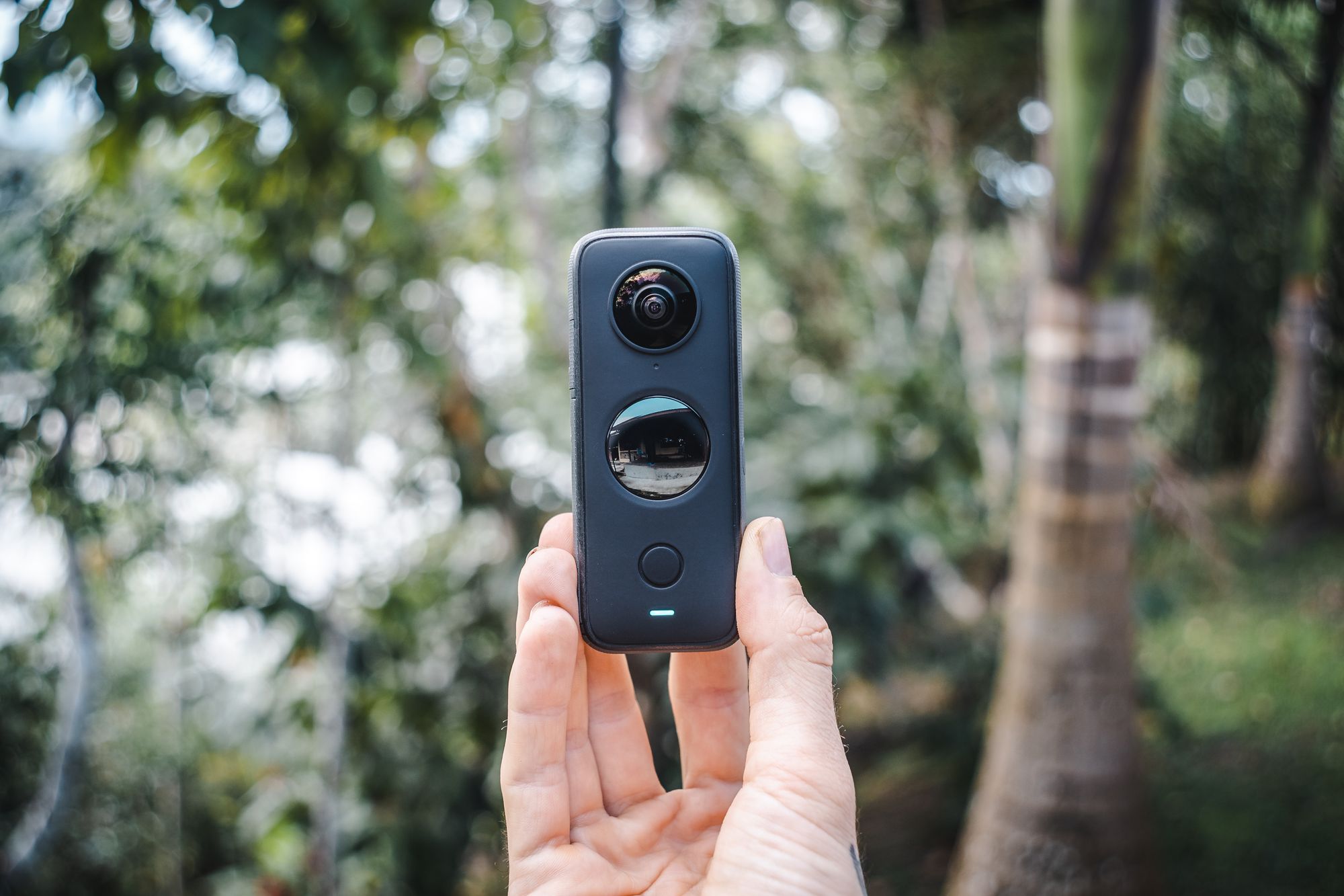

Online Communities for Real Estate Marketers
TeliportMe invites you to join their Virtual Tour Marketing Community of forward-thinking real estate professionals, business owners, and professional photographers. We share insights, tips, and the latest trends in leveraging virtual tours for maximum impact.
🚀 Why Join?
- Gain exclusive access to industry experts and thought leaders.
- Exchange ideas and strategies with like-minded professionals.
- Stay updated on cutting-edge technologies and tools in virtual tour marketing.
- Collaborate on innovative ways to make your listings stand out.
Interested in learning more about real estate photography?
We suggest the following articles:
]]>Embarking on the journey to create 360-degree virtual tours doesn't have to break the bank, and our readers seeking free solutions are in the right place.
Crafting a virtual tour is impossible without the right software, but fear not—there are fantastic free options that offer essential features for transforming static images into captivating 360-degree experiences.
In this article, you'll discover the best free virtual tour solutions to include in your digital toolkit in 2024. Plus, you don't need to be a professional photographer to take advantage of all the advanced features as our recommendations cater to users of all skill levels.
What exactly is a virtual tour?
A virtual tour is an immersive experience that enables users to explore a physical space virtually, utilizing a compilation of 360-degree images. Compared to static images, it offers a more realistic experience of being physically present within a given space.
Accessible on various devices, including virtual reality (VR) headsets, mobile devices, and computers, virtual tours find utility across diverse industries. They play a significant role in marketing real estate, event venues, tourist destinations, museums, and educational institutions.
Why are virtual tours important?
Virtual tours are important for a few key reasons:
- Enhanced Accessibility: Virtual tours let people check out places they might not reach physically due to distance, travel restrictions, disabilities, or budget constraints. It's a chance for everyone to experience a location online and feel its vibe.
- Added Convenience: You can explore virtual tours anytime and anywhere with an internet connection. This flexibility allows you to take your time exploring without worrying about time or location restrictions.
- Helpful Information: Virtual tours are handy in real estate, tourism, and business. They help you make decisions by letting you check out homes, destinations, or businesses virtually before committing. It's like a sneak peek before the actual visit.
- Marketing: Businesses use virtual tours to market themselves better. They provide a more detailed and interactive view compared to just pictures or descriptions. This can get people more interested and possibly lead to more sales.
- Education: Virtual tours are useful for learning. They let students explore places like historical sites or museums without actually going there. It makes learning more fun and helps you understand things better, especially when you can't visit in person.


Key Features of Virtual Tour Software
360° Image Support
360-degree image support is the hallmark of virtual tour software. This feature provides a comprehensive view of a space, allowing users to explore every angle and detail.
While all virtual tour software should be able to host 360-degree images, some providers go a step further by allowing you to capture panoramas directly with your mobile device. With a simple 360-degree spin, mobile devices can capture cylindrical panoramas. However, for spherical images (where viewers can pan to see overhead), you may need a specialized 360 camera.
Customizable Hotspots
Hotspots are interactive features that elevate user engagement by enabling clickable points within a virtual tour. Users can access additional information, explore various areas of interest, and uncover hidden details.
While basic virtual tour software includes this functionality, certain providers offer enhanced customization options, empowering users to tailor hotspots to their unique preferences and requirements.
Compatibility
Some virtual tour software makes it easy for you to explore from any device—whether it's your computer, phone, or even a virtual reality headset. Plus, they go a step further by smoothly connecting with popular platforms like Facebook, Google Maps, Google Street View, and others.
This means you can view and share virtual tours seamlessly across various platforms, enhancing your overall experience.
Interactive Elements - Videos, Audio, and Text Descriptions
Users can enhance the virtual tour experience by incorporating videos, audio files, and descriptive text to provide detailed information about specific points of interest.
This multifaceted approach adds layers of information, creating a more dynamic and educational virtual experience.
Analytics and Reporting
Virtual tour software often provides analytics and reporting tools to track user engagement, view statistics, and gather valuable insights for marketing purposes.
These features empower creators to understand their audience better and optimize their virtual tours for enhanced effectiveness.
.jpg)

How to Choose the Best Virtual Tour Software
When choosing a free virtual tour creation software, the following factors are most important:
- Functionality
- Ease of use
- Compatibility
- Customization
- Tutorials and customer support
Let's explore this in further detail:
Functionality: Before subscribing to a virtual tour software, ensure that it provides the essential features and tools to create immersive virtual tours effectively. Assess its ability to handle panoramic images, incorporate multimedia elements, and offer seamless navigation.
Ease of use: When selecting virtual tour software, prioritize a user-friendly interface that is intuitive and requires minimal training. Choosing software with these qualities ensures a swift and efficient virtual tour creation process. Many providers offer free trials, providing an excellent opportunity to explore the software's user-friendliness and functionality before making a commitment.
Compatibility: We recommend verifying that your chosen virtual tour software is compatible with diverse operating systems and popular social media platforms. This step ensures that your tours remain accessible to a broad audience, regardless of the device they use. Confirming compatibility with various platforms enhances the reach and engagement potential of your virtual tours.
Customization: Look for software that offers a variety of customization options. Being able to add your own branding, customize the layout and design, and incorporate interactive elements can make your virtual tours more compelling for your audience.
Tutorials and Customer Support: Check if the virtual tour software provides reliable customer support and resources. Having access to assistance, tutorials, and a community forum can be invaluable when you encounter issues or have questions during the tour creation process.

3 Best FREE Virtual Tour Software
#1 Best Overall: TeliportMe.com
TeliportMe is a powerful virtual tour software that allows users to create immersive tours with ease. It offers a user-friendly interface and intuitive tools for creating stunning virtual experiences. If you do decide to upgrade, it has the best features for the lowest subscription costs and also provides pay-as-you-go options.
Key Features and Functionalities of the Free Version
- Dedicated app allows you to capture 360-degree panoramas from your mobile device
- Drag-and-drop interface for easy tour creation
- Virtual reality (VR) compatibility for an immersive experience
- Interactive hotspots for adding additional information or multimedia content
- Sharing options to easily distribute your virtual tours
- Password protection
- 24/7 customer support
Limitations of the Free Version
The free version of TeliportMe provides a limited number of hotspot types, so your virtual tour may look somewhat basic.
Another drawback of the free version is that all tours will include TeliportMe branding. However, this is typical of most free software products and can be removed upon upgrading.
Applications
TeliportMe caters to a wide range of commercial industries, including real estate, hospitality, tourism, museums, educational institutions, and even insurance.
2. Marzipano
Marzipano serves as a standalone software designed to craft virtual tours using a series of panoramic images. Notably, it provides the option to export these tours as web applications, ready for immediate use. It is important to note that Marzipano functions best with either Firefox or Chrome.
Key Features and Functionalities of the Free Version
- User-friendly interface
- Customizable hotspots
- Option to export virtual tour as a web application
- Option to embed virtual tour into websites and social media platforms
- WebVR support
Limitations of the Free Version
Since launching its tool seven years ago, it has received minimal updates. While it has served its purpose admirably, the lack of ongoing support also suggests that it may not be the most suitable option for professional applications.
Furthermore, Marzipano necessitates self-hosting. This means that even small adjustments to your tour will require a series of steps, impacting your ability to edit quickly.
Applications
Marzipano is ideal for casual users or small-scale projects where periodic updates and real-time editing are not critical requirements.
3. Panoraven.com
Panoraven is a versatile virtual tour software that offers a range of features and functionalities for creating immersive experiences. It provides users with an easy-to-use platform to build interactive tours.
Key Features and Functionalities of the Free Version
- Use the service without registering
- Unlimited 360 image uploads
- Mobile compatibility for viewing tours on smartphones and tablets
- Social media integration for easy sharing of virtual tours
- Easy website embedding
Limitations of the Free Version
The most significant limitation of the free version is that it does not provide the ability to add hotspots, so you won't be able to link 360 panoramas together. In essence, this means that your virtual tours will consist of only one panorama.
Additionally, the free version does not allow commercial use. This limitation is essential to consider if you intend to create virtual tours for business promotion.
Applications
The free version of Panoraven is a great starting point for basic 360 image uploading and sharing. However, users looking for advanced features, such as hotspot functionality and commercial use, may find it worthwhile to explore the paid versions.
Interested in learning more about photography?
We suggest exploring the following articles:
]]>With virtual reality (VR) technology becoming more accessible, the popularity and applications of 360° images have skyrocketed. From real estate and travel to marketing and entertainment, industries across the board are leveraging the power of 360° images to deliver immersive experiences to their audiences.
Whether you're a seasoned photographer looking to expand your skill set or simply a hobbyist eager to explore new techniques, this guide will equip you with everything you need to know to make stunning 360° images that will leave your viewers in awe.
You can expect us to cover the following topics:
- What is a 360° image?
- 360° Camera vs. DSLR vs. Smartphone: Choosing the Ideal Option
- Equipment Recommendations
- 360° Image Stitching Software Recommendations
- Best Practices for Shooting 360° Images
- Best Practices for Editing 360° Images
- Overcoming Common Problems
- How to Create Virtual Tours with 360 Images
- How to Share and Display 360 Images
What is a 360° image?
Simply put, it's a photograph that captures a full 360-degree view around a particular scene or vantage point in a single image. It allows viewers to immerse themselves in the image and explore every angle, changing the way we perceive and interact with visual content.
360° Camera vs. DSLR vs. Smartphone: Choosing the Ideal Option
To generate a 360-degree image, you have 3 options: a 360 camera, DSLR, or smartphone.
A dedicated 360 camera is purpose-built for capturing panoramic images in a single shot. These cameras usually come equipped with specialized software for seamless stitching and processing, simplifying the creation of 360-degree visuals.
On the other hand, a DSLR, known for its versatility and high-quality imaging capabilities, provides another avenue for crafting 360-degree images. To achieve this, you'd typically capture a series of overlapping photos and then use specialized software to stitch them together into a cohesive panoramic view.
If budget and convenience are your top priorities, then using a smartphone to capture 360° images may be your best option. Smartphones, equipped with increasingly sophisticated cameras and user-friendly applications, offer a cost-effective and accessible means to delve into the world of panoramic photography.


Factors to Consider When Choosing Between a 360 Camera, DSLR, and Smartphone
When deciding between a 360 camera, DSLR, or smartphone for 360 image capture, consider the following factors:
- Image quality: If image quality is a top priority for you, a DSLR is likely the best choice.
- Versatility: If you value versatility, it may make more sense to invest in multiple lenses for a DSLR.
- Convenience: If you prefer a simple and hassle-free experience, a 360 camera or smartphone may be more suitable than a DSLR.
- Portability: If you frequently need to capture 360 images on the go, a compact and portable 360 camera or smartphone may be more convenient.
- Budget: DSLRs tend to be more expensive than 360 cameras and smartphones, so consider your budget in making a decision.
All options offer distinct advantages. Let's delve into the specific benefits of each.
Advantages of Using a 360° Camera:
- Easy to use: 360° cameras are designed specifically for capturing immersive content, which makes them user-friendly, even for beginners.
- All-in-one solution: With a 360 camera, you don't need any additional equipment or lenses to capture a 360 image.
- Compact and portable: 360 cameras are typically small and lightweight, making them convenient to carry and use in various locations.
Disadvantages of Using a 360° Camera:
- Image quality: Compared to DSLR cameras, 360 cameras may have lower resolution and image quality.
- Limited manual controls: Most 360 cameras have limited manual settings, which can restrict your creative control over the image.
- Stitching issues: Some 360 cameras rely on in-camera stitching, which may result in stitching errors or artifacts in the final image.
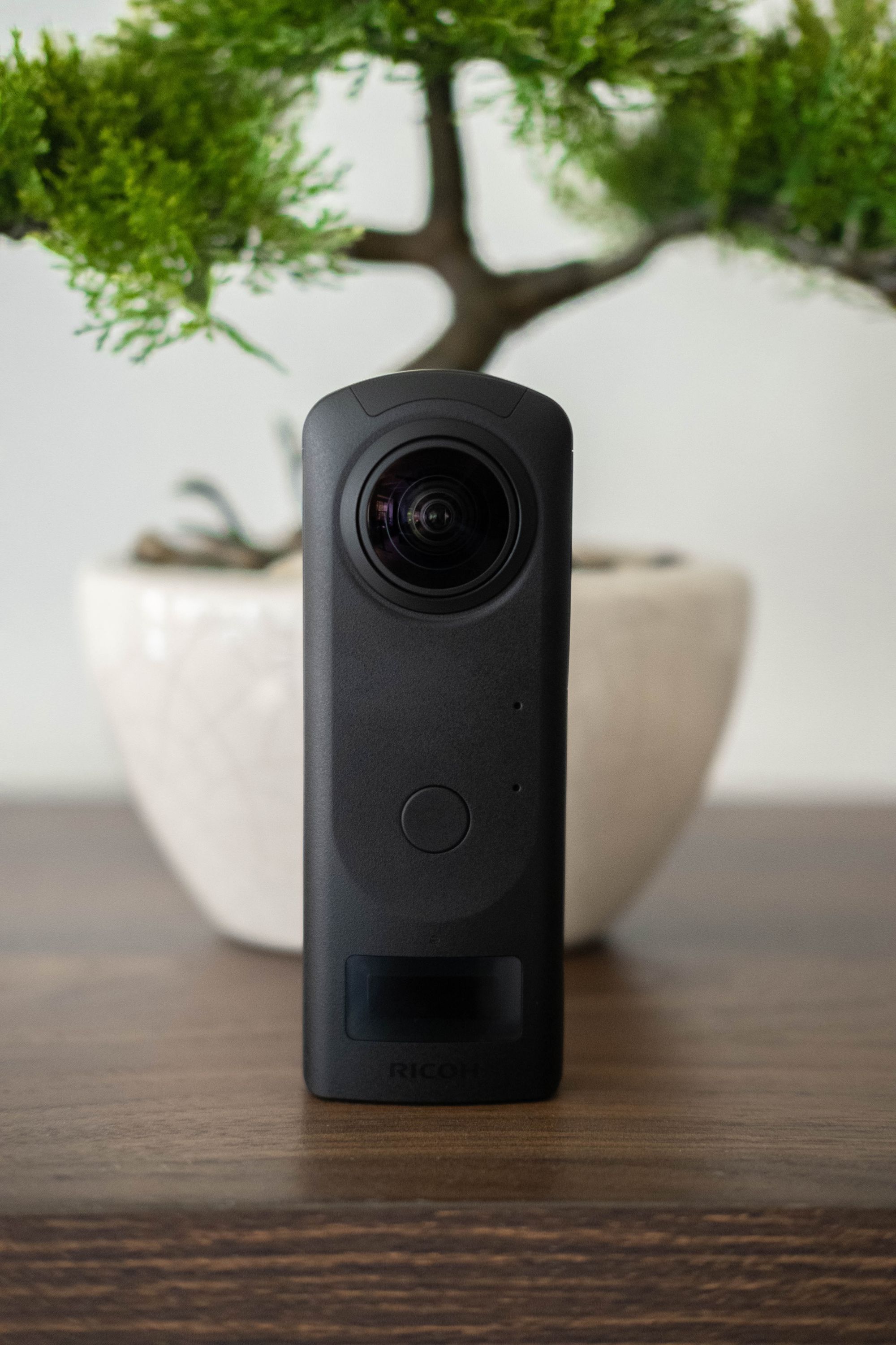


Advantages of Using a DSLR:
- Superior image quality: DSLRs typically deliver higher resolution and image quality compared to 360 cameras, making them an excellent choice for photographers who prioritize detailed and crisp visuals in their panoramic images.
- Advanced control: DSLR cameras offer a compelling option for capturing 360-degree images, especially for those who prioritize advanced control over key parameters like exposure and apperture. This level of control caters to experienced photographers who want to tailor each aspect of their 360-degree shots.
- Versatility in lenses: Unlike 360 cameras, DSLRs provide the flexibility to choose from a wide range of lenses, allowing photographers to experiment with different focal lengths, apertures, and perspectives. This versatility enables the capture of 360-degree images with varying visual styles and creative effects.
Disadvantages of Using a DSLR:
- Complexity and Learning Curve: DSLRs often have a steeper learning curve, especially for beginners. Understanding manual settings, lens options, and the stitching process for panoramic shots can be challenging for those new to photography.
- Cost: DSLRs and their accompanying lenses can be more expensive than 360 cameras, potentially posing a financial barrier for some photographers.
- More time-consuming: Unlike some 360° cameras that automatically stitch images within the camera, DSLRs require external software to piece together the shots. This extra step adds more time to the process of producing 360 images.


Advantages of Using a Smartphone:
- Convenience: Smartphones are highly convenient for capturing 360-degree images due to their portability and ease of use. The all-in-one nature of smartphones eliminates the need for additional equipment.
- Cost-Effective: Using a smartphone is a cost-effective solution since many individuals already own one. This eliminates the need for purchasing specialized cameras, making it a budget-friendly option.
- User-Friendly Apps: Smartphone photography apps are designed to be user-friendly, simplifying the process of capturing and stitching 360-degree images. This accessibility makes it an excellent choice for beginners.
Disadvantages of Using a Smartphone:
- Image Quality: While smartphone cameras have improved significantly, they may still have limitations in terms of image resolution and quality compared to dedicated cameras like DSLRs.
- Limited Manual Controls: Smartphone cameras often offer limited manual controls, restricting the ability to adjust settings such as exposure and focus for more advanced users.
- Storage Limitations: High-resolution 360-degree images can take up significant storage space on a smartphone. This limitation may require users to manage storage or transfer files to external devices.


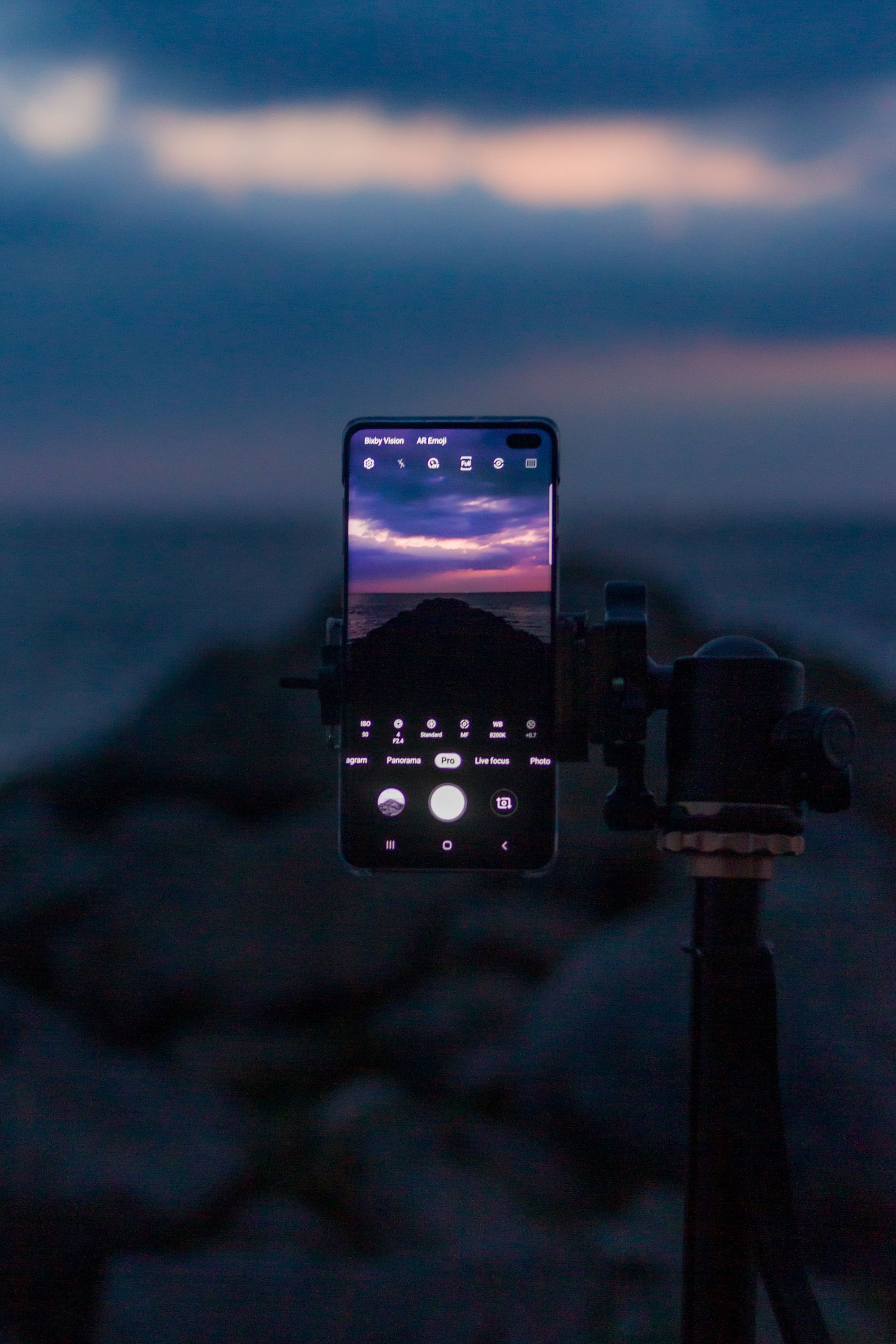
Equipment Recommendations
Creating stunning 360° images requires the right equipment. In this section, we'll explore the various options available for different needs and budgets.
360° Camera Recommendations
The following cameras offer advanced features and functionalities tailored for 360° image capture.
Best Overall: Insta360 ONE RS
Best Budget-Friendly: Trisio Lite2
Best Photo Quality: Ricoh Theta X
DSLR Recommendations
DSLRs with wide-angle lenses allow you to capture a wider field of view, perfect for creating panoramic images. We recommend the following setup:
DSLR + wide-angle lens + panoramic head
While the lens you purchase will ultimately depend on your DSLR model, the Sigma 8mm is a popular choice for Canon users.
A panoramic head is an tool that helps DSLR cameras capture precise and distortion-free panoramic images. By rotating the camera around its nodal point, it minimizes errors, ensures accurate alignment of images, and streamlines the post-production workflow. This accessory enhances image quality, versatility in composition, and overall efficiency when creating 360-degree images with a DSLR camera.
For a panoramic head, we recommend the Nodal Ninja 6.

Additional Equipment for Capturing 360° Images
In addition to the camera, there are a few essential pieces of equipment that are necessary for capturing high-quality 360° images.
- Tripod: Using a tripod helps eliminate camera shake, resulting in sharper and clearer images.
- Remote trigger: Remote triggers allow you to capture images without physically touching the camera, which further reduces camera shake.
- Additional charging equipment: Spare batteries for your DSLR provide extended shooting time, serve as a backup for unforeseen circumstances, and ensure uninterrupted photography in remote locations or during important events.
By incorporating this equipment into your setup, you can ensure stability and minimize unwanted movement during the image capture process.

360° Image Stitching Software
Stitching multiple images together is a crucial step in creating a seamless 360° image. To achieve this, you will need reliable software that can effortlessly merge your photos.
PTGui
PTGui is a dedicated software designed specifically for panorama stitching, including 360° images. It offers a user-friendly interface and advanced features, such as exposure correction, alignment optimization, and control points. PTGui supports various file formats and has a built-in ability to straighten and mask out unwanted portions of your images, resulting in a seamless panorama.
Hugin
Hugin is another powerful open-source software that specializes in panorama stitching. It provides an intuitive interface and advanced features for aligning and blending images to create stunning panoramas. Hugin supports a wide range of file formats and offers control over individual image parameters, allowing you to fine-tune your final output.


Best Practices for Shooting 360° Images
When it comes to creating impressive 360° images, there are several tips, tricks, and best practices that can help you achieve high-quality results. In this section, we will explore some of these techniques to elevate your 360 image creation skills.
When shooting 360° images, we suggest the following:
1. Position your camera appropriately.
Ensuring the proper positioning of your camera is essential for capturing a comprehensive 360° view. Generally, it is advisable to place your camera around 5 feet from the floor. However, adjustments may be necessary based on specific scenarios.
For instance, when photographing a spacious room with high ceilings, you might need to raise the camera height slightly. Conversely, if your intention is to highlight an intriguing floor, positioning the camera lower than the usual 5 feet could be more effective.
The key is to adapt the camera height to the unique characteristics of the scene you are capturing, optimizing the composition for the best results.
2. Use a tripod.
Handheld shots can introduce camera shake, especially in low-light conditions or longer exposure times.
The utilization of a tripod eliminates camera shake through the implementation of image stabilization, leading to sharper and clearer images in the final 360-degree composition.
3. Maximize image quality.
Maintaining a clean camera lens is crucial to avoid unwanted smudges or dirt that might compromise image quality.
Consider opting for the RAW format. Unlike JPEG or other compressed formats, RAW files retain all the information collected by the camera's sensor during the exposure, without any in-camera processing. RAW files are considered the digital equivalent of a film negative, preserving the maximum amount of detail, color information, and dynamic range captured by the camera.
Achieving optimal results may involve adjusting exposure, aperture, and white balance settings on your camera. Experimenting with these settings allows you to find the right balance tailored to your specific shooting conditions, ensuring accurate colors and details in your final 360° image.
Additionally, explore High Dynamic Range (HDR) techniques to capture a wider range of colors and tones, particularly useful in scenes with varying levels of brightness and contrast.
4. Take time to consider composition.
Although the rule of thirds may not be a primary concern when capturing panoramic images, it's advisable to focus on incorporating captivating foreground elements.
For example, consider including a visually interesting element in the foreground, such as a striking rock formation, a vibrant flower, or a reflective body of water. By doing so, you not only capture the expansive beauty of the landscape but also infuse the image with a sense of scale and depth.
5. Avoid parallax issues.
Parallax errors occur when objects in the foreground and background do not align correctly during the stitching process.
To avoid this, you will need to pivot around the nodal point and take images that overlap. This will minimize any misalignment and ensure seamless stitching in your final 360° image.

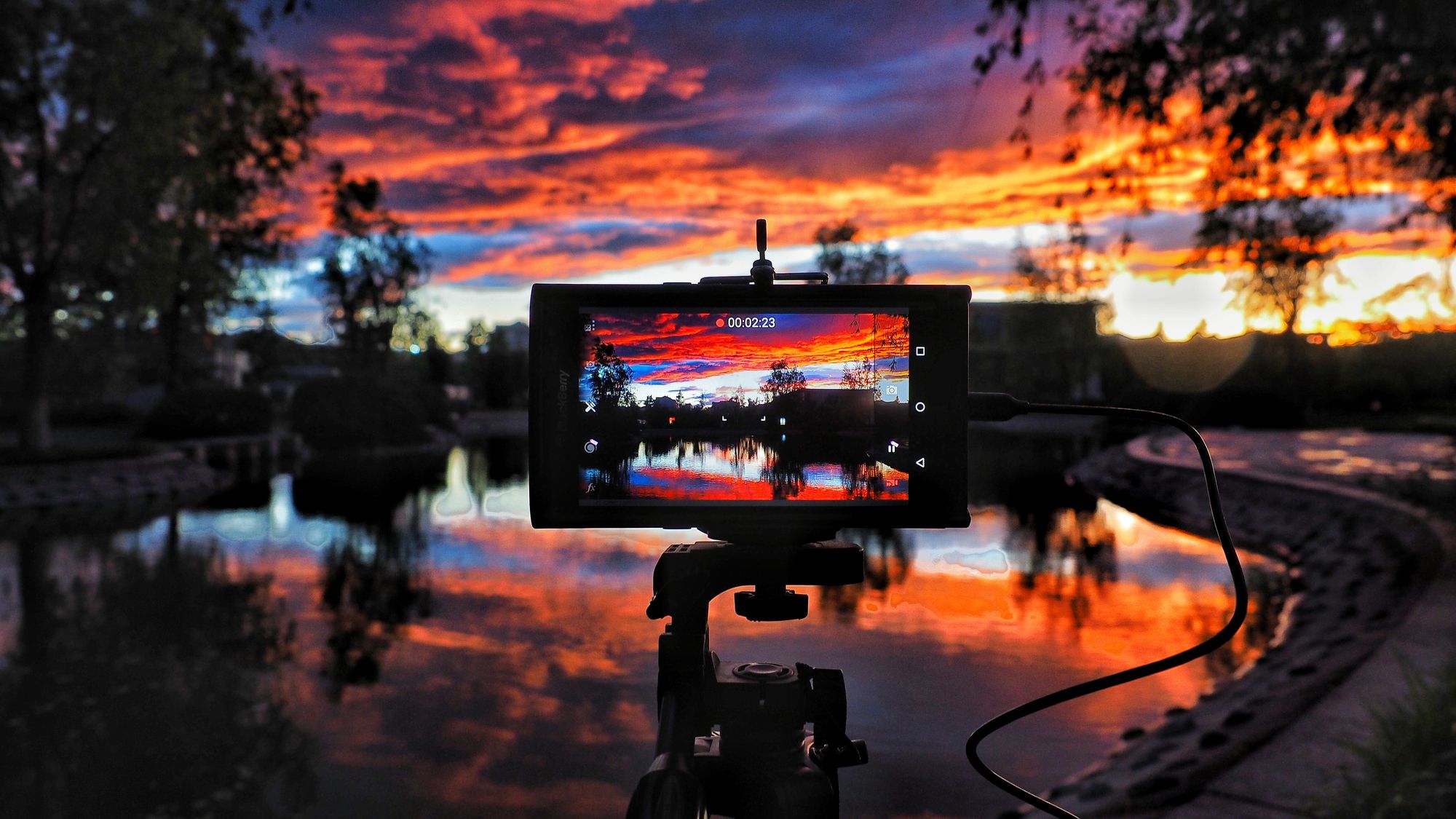
Best Practices for 360° Image Editing
Once you have captured your images with the right equipment and mastered the stitching process, it's time to take your images to the next level through image editing. This crucial step allows you to enhance the overall quality and aesthetic appeal of your 360 images.
Here are some best practices to help you achieve outstanding results:
1. Enhance image quality.
- Utilize sharpening tools or apply noise reduction to bring out fine details or minimize blurry images.
- Adjust the white balance to ensure accurate colors and eliminate any unwanted color casts.
- Experiment with different color temperature settings and special effects to evoke different moods or enhance specific elements in your image.
- Tweak the brightness and contrast levels to add depth.
2. Remove unwanted elements.
- Use the content-aware fill tool to intelligently remove any objects or people that may have unintentionally appeared in your image.
- Use the clone stamp tool to remove any distracting elements or imperfections.
- If you have captured a 360° image with a tripod, utilize the clone stamp or healing brush tool to eliminate any visible tripod shadows.
3. Optimize for different platforms.
- Consider the specific requirements of various platforms where you plan to showcase your 360° images.
- Resize your images to fit the desired display dimensions without sacrificing quality.
- Optimize your images for web or mobile platforms to ensure fast loading times and optimal viewing experiences.
By implementing these editing and retouching techniques, you can transform your 360 images into visually captivating masterpieces that leave a lasting impression on your viewers.
Overcoming Common Problems
In this section, we will delve into common mistakes that often occur during the capture and processing of 360 images, offering solutions and tips for effectively overcoming these challenges.
Glare Issues
Glare can be a major problem when shooting in environments with excessive lighting. It can result in overexposed areas in your images, causing loss of detail and visual appeal.
Stitching Errors
Incorrect alignment of individual images can lead to distorted perspectives and uneven stitching, affecting the overall quality of your 360 image.
Mismatched Exposures
Inconsistent exposures among the frames used for stitching can create noticeable differences in brightness or contrast within the final image, disrupting the overall visual harmony.


How to Create Virtual Tours with 360 Images
Creating virtual tours from 360 images allows you to provide users with an immersive and interactive experience. By incorporating hotspots, navigation, and interactivity, you can guide viewers through a virtual space and provide them with a unique way to explore different areas.
To create virtual tours from your 360 images, follow these simple steps:
- Select specialized software: There are various software options available for creating high-quality virtual tours from 360 images. Consider using platforms like TeliportMe, KRPano, or Pano2VR, which provide user-friendly interfaces and a range of features.
- Import your 360 images: Once you have chosen your preferred software or platform, import your 360 images into the platform's interface.
- Arrange the sequence: Arrange your 360 images in the desired sequence to create a logical flow for your virtual tour.
- Add hotspots: Hotspots are clickable areas within the virtual tour that allow viewers to navigate between different images or access additional information. Add hotspots to connect your 360 images and create a seamless navigation experience.
- Customize navigation: Customize the navigation options within your virtual tours, such as arrows or menus, to make it easy for viewers to explore different areas.
- Incorporate interactivity: Enhance the interactive capabilities of your virtual tour by adding additional multimedia elements like videos, audio, or text descriptions.
- Preview and test: Before sharing your virtual tour, preview and test it to ensure a smooth and engaging experience for viewers.
By following these instructions, you can create captivating virtual tours from your 360 images and offer users an immersive way to explore your chosen spaces.
How to Share and Display 360 Images
Once you've created your stunning 360 images, it's time to share them with the world. Whether you want to display them on social media platforms, websites, or virtual reality (VR) platforms, here's a guide to help you get started.
Choose a platform.
Several digital platforms and websites specialize in hosting and displaying 360 images, providing an immersive experience for your viewers:
- TeliportMe: TeliportMe is a popular platform that uses cutting-edge technology to allow users to create and share 360 images. It offers a user-friendly interface and various customization options.
- Facebook: Facebook is another excellent platform where you can host and showcase your 360 images. It does not support high-resolution images but provides embedding options for websites and blogs.
- Google Street View: Google Street View is a widely used platform for sharing 360 images and creating virtual tours. It integrates seamlessly with Google Maps and offers extensive visibility.
Sharing your 360 images on these platforms is a straightforward process. Simply create an account or sign in, navigate to the upload page, and follow the instructions to select and upload your images. After uploading, you can customize the settings, add descriptions, and share your images with others.
Additionally, these platforms allow you to embed your 360 images on websites and share them on social media. Make sure to utilize these features for maximum exposure and engagement.
Choose a suitable file format.
When it comes to sharing 360 images, it's important to choose the right image file format for your platform. The most commonly used formats are JPEG and PNG. JPEG is ideal for its compression capabilities, balancing file size and image quality. On the other hand, PNG is preferred when a higher quality and lossless compression is required.
In addition to these standard formats, some cameras and software may use proprietary formats that offer additional features or capabilities. It's essential to check the compatibility of these formats with the platforms on which you intend to share your images.


Join Our Community
If you're interested in joining the largest community of 360-degree photo enthusiasts, we encourage you to join TeliportMe.
Create a free account and become part of our 15 million users strong community where you can share and view stunning 360-degree panorama images with fellow enthusiasts.
Sign up now and start exploring the panoramic world!
]]>Investing in virtual tours benefits both property owners and insurance companies. For owners, it streamlines claims with detailed property records, reducing potential disputes. Insurers gain efficiency, cost savings, and accurate property assessments, leading to quicker claims resolutions.
In this article, we'll discuss how virtual tours benefit both insurance companies and customers, highlighting common use cases for each.
Index:
You can expect us to cover the following topics:
- Who can benefit from virtual tours in the insurance process?
- Benefits of virtual tours for insurance purposes
- Video vs. virtual tour: Which is better for insurance purposes?
- What is the best virtual tour software for insurance?
- How to get started

Who Can Benefit from Virtual Tours in the Insurance Process?
- Property Owners
- Claims Adjusters
- Underwriters
- Legal Teams
Let's explore how in further detail:
Property Owners
Since virtual tours can be used to document the condition and contents of a property, property owners have a compelling reason to invest in them. This investment is essential for ensuring accurate assessments, expediting claims processing, and offering comprehensive protection against unforeseen events.
Use Case:
In the United States, around 358,500 house fires occur every year. In the unfortunate event that this happens to you, your insurance company may require you to create a total loss inventory list. For most people, remembering every item that was lost can be challenging. It may be even more challenging to prove that your property was in good condition before the fire.
If you worry that you might face such a situation, it's prudent to create a comprehensive record of your property before a disaster occurs. A virtual tour can help you create a detailed inventory of your possessions, ensuring you can fair compensation in the claims process. Furthermore, it can act as shareable proof of the quality of your property before the fire, reducing disputes and facilitating a quicker claims settlement.
Claims Adjusters
Claims adjusters benefit significantly from virtual tours as they streamline the assessment of damages, making the claims resolution process faster and more efficient. The ability to remotely inspect a property through a virtual tour may even eliminate the need for physical visits, saving time and resources.
Use Case:
After a storm, a claims adjuster may need to assess damages to multiple properties quickly. With virtual tours, this process becomes more efficient as they can remotely inspect the affected properties from their desk. Instead of traveling to each location, the detailed 360-degree views and documentation provided enable them to gauge the extent of the damages accurately. This not only expedites the claims process but also allows claims adjusters to allocate their time more effectively, ensuring a prompt and fair assessment for each policyholder affected.
Underwriters
Insurance underwriters evaluate risks related to insurance applications by analyzing data like an applicant's history and property details. In this process, a virtual tour can be a useful tool, aiding underwriters in making well-informed decisions about coverage terms, premiums, and whether to approve or reject a policy based on a comprehensive risk analysis.
Use Case:
While underwriters typically rely on data, analytics, and documentation for their assessments, there are instances where a personal inspection of a commercial property may be deemed necessary. However, in many cases, underwriters can leverage technology, such as a virtual tour, to gather comprehensive information without the need for a physical visit. A virtual tour can be particularly useful, providing a detailed and immersive view of the property, helping underwriters assess risk factors, property conditions, and overall insurability more efficiently.
Legal Teams
In the aftermath of a property-related incident, legal teams need to navigate claims disputes and address legal implications. Virtual tours become a useful problem-solving tool because they provide a visual record of the property's condition before the event. This documentation not only aids in supporting the claims process but also serves as tangible evidence in legal proceedings.
Use Case:
In the case of a house fire, a property owner may seek considerable compensation. In some cases, there might be disagreements between legal teams about the extent of the damages or the condition of the property before the incident. The virtual tour becomes essential in these situations, offering a clear and unbiased record. Legal teams use it to show exactly how the property looked before the event, including its features and contents. This visual evidence helps in negotiations and legal discussions, making the resolution of disputes more transparent.

Benefits of Virtual Tours for Insurance Purposes
1. Efficient Claims Processing: Virtual tours serve as invaluable documentation for insurance claims. Insurers can refer to the comprehensive footage and images to verify a property's condition before an incident, expediting the claims process and reducing disputes.
2. Comprehensive Visual Representation: Virtual tours offer a detailed and immersive visual representation of insured assets, minimizing misunderstandings and enhancing communication between insurance companies and policyholders.
3. Secure and Unalterable Records: Unlike traditional documentation methods susceptible to damage or manipulation, virtual tours are hosted on secure servers, ensuring the integrity and longevity of captured data. This feature becomes particularly crucial in maintaining records during unforeseen events like fires or floods.
4. Remote Accessibility: The accessibility of virtual tours enhances the efficiency of the insurance claims process. Insurers can remotely access and review tour content, eliminating the need for on-site visits, thereby expediting claims assessment and contributing to a streamlined and customer-friendly experience.
5. Peace of Mind for Policyholders: Virtual tours provide policyholders with peace of mind, knowing that their insurance claims are supported by a detailed, tamper-proof visual record. This transparency fosters trust, reduces the likelihood of disputes, and ensures fair and accurate assessments of claims.

Video vs. Virtual Tour: Which is Better for Insurance Purposes?
While making videos of your belongings for insurance is better than nothing, virtual tours offer significant advantages.
Firstly, they come with advanced features, such as the ability to embed photos, videos, PDFs, and even sounds. This practical feature allows you to directly save receipts and other additional information within your virtual tour, making it easy to access crucial documents. For example, when you hover over your sofa or a piece of art, you can instantly access the associated receipts. This streamlined capability ensures that insurance professionals and users alike can securely store and retrieve all essential details.
Additionally, virtual tours provide independent navigation through spaces. This self-driven exploration becomes invaluable during insurance claims assessments, allowing for a comprehensive and user-directed examination of specific areas of interest.
Moreover, virtual tours are hosted on protected servers, ensuring the safety of critical information even if physical receipts are lost in an unforeseen event. To address privacy concerns, users have the option to password-protect their virtual tours, adding an extra layer of security to their documentation process.

What is the Best Virtual Tour Software for Insurance?
TeliportMe sets a new standard in virtual tour software for insurance, offering a holistic solution that caters to the needs of the insurance industry.
Here are some key aspects that set TeliportMe apart:
Security: TeliportMe prioritizes the security of user data, underscoring its commitment to safeguarding critical information. By hosting virtual tours on secure servers, TeliportMe ensures the integrity and protection of user data, establishing a trustworthy foundation for insurance documentation.
Accuracy in Digital Representation: TeliportMe excels in providing accurate and detailed digital representations of properties. Utilizing sophisticated algorithms and state-of-the-art technology, the platform captures and preserves a three-dimensional visual record of your assets.
User-friendly Interface: You don't need a computer science or photography degree to create a virtual tour with TeliportMe. The platform is designed with user-friendliness in mind, allowing users to effortlessly navigate the software using just a smartphone. This accessibility ensures that creating virtual tours is a straightforward process for all users.
Advanced Features: Despite its user-friendly nature, TeliportMe doesn't compromise on advanced features. The inclusion of tools like 3D Dollhouse sets TeliportMe apart, providing users with powerful capabilities to enhance the documentation process.
Customer Service: TeliportMe's commitment to customer service is its hallmark feature. The emphasis on addressing user needs, providing prompt assistance, and offering reliable technical support underscores their dedication to ensuring a positive and seamless experience for all users.
How to Get Started
TeliportMe is confident that you'll fall in love with their software, which is why they provide an unlimited free trial. During this trial period, you'll have the opportunity to create your own virtual tour and explore all the features without the need to provide any credit card information. The only limitation is that you won't be able to publish your virtual tour until you're ready to fully commit to using the platform.
If you have any questions about virtual tour software, please contact us at help@teliportme.com. We are the industry experts, and our goal is to make the process as simple as possible for you.
Safeguard your precious assets
Start a Free trial with TeliportMe Virtual Tour Software
Start Free TrialReal estate agents have warmly embraced new technologies to simplify transactions for their clients. Gone are the days when 360° virtual tours were a simple addition to the real estate marketing arsenal, intended exclusively for dream properties. There was a time of confusion, when clients would ask for a virtual tour, only to be sent to a humble video.
But now, thanks to their accessibility, 360° virtual tours have become a must-have element of real estate marketing. Buyers and sellers are well aware of the differences between slideshows, virtual tours and video tours.
In this blog we will take a look at these two marketing strategies, detailing their benefits to help you choose the best option for your real estate agency.
Index:
- What are 360° virtual tours?
- What are video tours?
- Which is best for you?
- Getting started with 360 tours
What are 360° virtual tours?
A 360 tour is a series of panoramic images captured with a 360 camera and edited to create a virtual experience. Virtual tours provide an interactive experience because viewers can click on specific areas and look at them from particular angles. 360 tours also allow the viewer to zoom in, quickly identifying intricate details that are not possible in video tours.
Benefits of virtual tours
There are several reasons why buyers and sellers in the real estate market prefer virtual tours to video tours.
360 tours provide immersion:
3D tours make users feel as if they are inside the house, walking through it. They make it much easier to get a feel for the property and decide whether to view it in person.
The immersive aspect of the tours comes from the 360° camera required for the task. Even the best cameras used in a video tour lack this technological feature, a deficiency that prevents them from catching up with this crucial capability to make videos immersive.
Virtual tours are self-guided:
A significant difference between virtual tours and video tours is that virtual tours are self-guided and interactive. They allow viewers to choose their real estate adventure, an element that provides self-direction and control. When buyers have this freedom, they have no reason to switch to video tours that are somewhat limiting.
You can host virtual tours but not video tours:
Virtual tours, unlike video tours, can be arranged, which was one of the first breakthroughs in the prop technology revolution. In the past, agents considered virtual staging to be an infringement of real estate marketing until they realised how well it works to meet buyers' needs. The approach is also cost-effective compared to physically staging a property.
Research shows that virtual staging:
- Allows agents to sell homes they stage 75% faster than those they do not stage.
- Increases the chances of selling a home for the asking price or more by 85%.
- Allows real estate agents to offer buyers different looks for the same space.
- Eliminates the feeling of emptiness that emanates from most unfurnished listings.
Virtual tours do not depend on a long attention span
360° virtual tours have a different layout than video tours. The video experience is linear; it begins and ends when the camera operator and video editor indicate it should. If a shopper is interested in seeing the bathroom, they must wait for the photographer to take them there. The other alternative is to fast-forward the video to locate the bathroom. Doing this provides zero interactivity, which can be problematic in this age of shrinking viewer attention spans.
360 tours put control in the hands of the viewer, allowing them to explore the property at their leisure. Everything happens within their time frame and convenience. Tours engage the viewer in exploration, unlike videos that leave them wondering what other videos they might be watching.
Virtual tours are affordable
Many are surprised by how affordable a 360° virtual tour is. Typically, a 5,000-square-foot home can be completed for less than $400 USD, a one-time fee. A business can add a Google Virtual Tour to its Google Business listing for less than $500. About a third of the cost of making a professional video.
Of course, you can save money by making a video yourself on a smartphone. Unfortunately, they usually look unprofessional. Defeating the purpose.


What are video tours?
Video tours are short videos of the key elements of a property. Someone walks through each room, recording the videos. The idea is to provide additional context to the design of the house beyond what the images can provide. Unlike virtual tours, a video tour has minimal editing and the filming is often done on a mobile phone.
The most immediate benefit of video tours, primarily for the marketer, is that they are quick to create. They also do not attract a substantial upfront investment, as all you need is a mobile phone with high-quality video capability, unlike virtual tours, which require single cameras. With basic editing skills, it's easy to add a logo to the video, some music and a voiceover in the background.
Which is best for you?
When deciding whether to use 3D tours or video tours for your needs, remember that there are no right or wrong choices. The decision depends largely on what you want to achieve, as both marketing strategies have the following benefits:
- They reduce the number of unnecessary viewings by providing more information about the layout of the property.
- They increase a buyer's interest in listings, thus generating more leads.
Increase listing engagement and encourage more clicks to your site. - They are easy to share on social media, which extends your reach to potential buyers.
Your budget, potential buyer and type of property in question are the crucial factors in helping you make the final decision. Video tours are a great option if you want to publish marketing materials quickly and easily. They provide additional content to the home when done professionally.
Getting started with 360 tours
Once you use 360° virtual tours to market your listings, you'll want them to be professionally done to get the greatest return on investment. TeliportMe was born in 2010 with a lofty goal - to help create the world's first crowdsourced Streetview and is currently being used by more than 25,000+ small businesses all over the world.
In the recent past, homes sold like hotcakes and the speed factor was not as important. Now, with rising mortgage rates and stagnant markets, it is becoming a key factor. So why do listings that include a 360 tour sell for more? It's quite simple. The more people you can get to see the home, the more likely you are to find a buyer willing to pay a higher price.
Contact us today to schedule a free consultation, even if you're not sure which option to choose.
Elevate your Agency strategy
Start an Unlimited Free Trial with TeliportMe Virtual Tour Software
Start Free Trial.jpeg)
In this comprehensive guide, we will walk you through the essential steps to succeed with real estate aerial photography. We break down everything you need to know to master the art of capturing aerial shots for real estate marketing. From understanding airspace regulations to selecting the right equipment and getting all the right angles, we've got you covered.
No comprehensive guide would be complete without an index, allowing you to easily navigate to the specific information you need. Below, you'll find a detailed index of the topics covered in this ultimate guide to real estate drone photography:
Index:
- Introduction
- How can a real estate photographer benefit from using drones?
- Which properties benefit from aerial drone photography?
- Selecting the Best Drones for Real Estate Photography
- Operating Requirements
- Registering your drone
- Obtaining a Remote Pilot Certificate
- How to Prepare Real Estate Listings for Drone Photography
- Optimal Weather Conditions for Drone Photography
- What time of day is best for drone photography?
- How to Capture All the Necessary Angles
- Aerial Drone Photography Pricing

Introduction
As cell phone cameras have become more advanced, real estate professionals now have access to high-quality cameras right in their pockets. They can easily snap a few shots of their property listing and call it a day.
To truly stand out, real estate photographers must be able to deliver something beyond the ordinary.
Incorporating drone photography into your repertoire can have a substantial impact on your business. Given the specialized skill set and level of experience needed to capture aerial images, offering this service can help you win more business and command higher rates.
How can a real estate photographer benefit from using drones?
Real estate photographers benefit in various ways by incorporating drones into their photography toolkit. Here are some key advantages:
1. Expanded Services: By offering drone photography services, real estate photographers can diversify their offerings and attract a broader range of clients. This allows photographers to tap into the growing demand for aerial imagery in the real estate industry.
2. Unique Perspectives: Drones provide photographers with the ability to capture eye-catching visuals and showcase properties to their best advantage. The dramatic perspectives help photographers stand out and leave a lasting impression.
3. Increased Demand: Aerial photography has become increasingly popular in the real estate market. Many clients now specifically request aerial shots to showcase the property's size, location, and surrounding environment. Aerial photographers can leverage their added level of experience to expand their client base.
4. Enhanced Visual Appeal: Aerial photography adds a sense of grandeur and scale to real estate photos, making them more visually appealing. The wide-angle views captured by drones can showcase the entire property, emphasizing its features, layout, and surroundings, ultimately attracting prospective buyers.
5. Highlighting Property Features: Drones allow photographers to capture close-up shots of unique property features that may be difficult to showcase from the ground. This includes architectural details, outdoor amenities, landscaping, and more. By highlighting these distinctive elements, photographers can help clients effectively market their properties.
6. Competitive Advantage: Real estate photographers who offer drone photography services gain a competitive edge in the industry. High-quality aerial images and videos set their work apart from traditional real estate photos, making listings more attractive to potential buyers. This can lead to increased client satisfaction, more referrals, and a stronger professional reputation.
7. Creative Storytelling: Drones enable photographers to create engaging and immersive property videos by combining aerial footage with ground-level shots. This allows for the seamless storytelling of a property's unique features, flow, and lifestyle. Such creative visuals can evoke emotions and better connect with viewers, increasing the chances of a successful sale.
8. Professional Development: Incorporating drones into real estate photography requires acquiring new skills and staying updated with regulations. By embracing this technology, photographers can expand their expertise, remain at the forefront of industry trends, and continuously improve their craft.
By leveraging the benefits of drone photography, real estate photographers can enhance their services, attract more clients, and achieve greater success in a competitive market. It opens up new opportunities for creativity, differentiation, and professional growth in the field of real estate photography.
Which properties benefit from aerial drone photography?
Your primary criteria for deciding whether to utilize drones for capturing aerial footage is simple: Will it enhance the property's marketability and make it easier to sell?
Certain types of properties inherently benefit from aerial photography.

Beachfront properties and lakefront properties gain a significant advantage from aerial shots that showcase their proximity to the water. Larger properties with sprawling grounds and extensive landscaping can also greatly benefit from aerial photography, as it allows potential buyers to fully appreciate the scale and layout of the property.
Properties in desirable locations also benefit from aerial photography because it can effectively highlight their prime location. For commercial properties, location is a critical determinant of value, making it advantageous to show off this aspect.

Additionally, high-end properties that boast special features like tennis courts, roof decks, pools, hot tubs, or other unique amenities can leverage aerial photography to showcase these standout elements and create a captivating visual representation.
On the other hand, there may be instances where aerial photography may not be the optimal choice. For example, if your property is situated in a heavily wooded area, potential homebuyers may not be so interested in aerial shots that primarily feature the tops of trees. Similarly, if your property listing is located in close proximity to less-desirable elements, such as a power plant or a noisy highway, emphasizing these aspects through aerial photography may not be advantageous in the selling process.


By thoughtfully analyzing these factors, you can make an informed decision about whether to leverage the power of aerial photography for the real estate business.
Selecting the Best Drones for Real Estate Photography
With such a wide variety of both premium and cheap drone models available on the market, it can feel overwhelming to choose the right one. You want the type of drone that's easy to fly, has the capacity to take amazing shots, won't disappear in a puff of wind, and can endure more than a few minutes of flight time. Given this criteria, here are our top picks:
Budget-friendly:
The DJI Mini 2 is compact and affordable drone, making it an excellent entry-level option for those on a budget. Priced at around $400, it offers a good balance between affordability and performance. Customer impressions of the DJI Mini 2 have been overwhelmingly positive, with many users praising the drone's capabilities and the quality of aerial photographs it produces. Customers have found their images to be of more than acceptable quality, often remarking on the impressive level of detail and clarity captured by the Mini 2's camera.
The compact design of the Mini 2, folding to the size of a person's hand, makes it highly portable and easy to carry on your adventures. Weighing less than 249 grams, this drone falls below the weight threshold that requires registration for personal use. (If you are planning to use it for real estate drone photography work, you'll need to register it.)
Despite its smaller size, the Mini 2 doesn't compromise on essential features. It features a 12-megapixel camera capable of capturing 4K videos and impressive aerial photos. With a maximum flight time of up to 31 minutes, this type of drone also comes with intelligent flight modes and advanced safety features, making it ideal for beginners and those looking for a user-friendly experience at an affordable price.
Price: ~$450
High-performance:
The DJI Air 2S is the ultimate drone for capturing breathtaking aerial photography and videography.
One of the standout features of the DJI Air 2S is its powerful 1-inch CMOS sensor, capable of capturing stunning 20-megapixel photos and 5.4K ultra-high-definition videos. This means you can capture every detail with exceptional clarity and vivid colors, ensuring that your aerial shots truly stand out.
It has an impressive maximum transmission range of up to 12 kilometers (7.5 miles) when operating in an open and unobstructed environment. This extended range allows you to explore vast areas and capture breathtaking aerial footage from a distance.
The DJI Air 2S is also equipped with an intelligent Automatic Return to Home (RTH) feature, ensuring a safe and worry-free flying experience. With this feature enabled, the drone can automatically navigate back to its takeoff point if it detects low battery levels, loss of signal connection, or if you manually initiate the return.
Price: ~$1000
Serious Upgrade:
The advancements in features makes the DJI Mavic 3 a compelling upgrade option for those who are willing to invest significantly more. For an additional cost, the Mavic 3 delivers clearer and more vibrant aerial videos and photos, complemented by the Hasselblad-branded camera for exceptional image quality. Moreover, the Mavic 3's advanced obstacle detection technology allows it to sense and avoid obstacles from multiple directions, contributing to a safer flying experience.
During flight, the Mavic 3 employs a network of sensors to detect obstacles from the sides, front, back, bottom, and top. This comprehensive coverage enables the drone to autonomously adjust its flight path, effectively avoiding potential collisions. Unlike the Air 2S, the Mavic 3's side sensors provide additional obstacle detection capabilities.
This drone has a range of up to 18.65 miles, however it's important to note that federal regulations require you or a designated spotter to maintain visual contact with the drone at all times.
Price: ~$2,400
Potential Drawbacks of DJI:
In recent years, DJI, like other China-based brands, has faced scrutiny from the US government regarding security concerns. These concerns have prompted a closer examination of the company's practices and raised questions about the protection of user data and privacy.
Furthermore, for Android users, it's worth noting that the DJI Fly app is not available for download on the Google Play store. Instead, users are required to download the app directly from DJI's official website. This deviation from the traditional app store distribution may be seen as an additional step in terms of app installation for Android users.
Alternative:
If you're seeking an alternative to the DJI brand or are interested in a 6K camera, the Autel Robotics Evo Lite+ is a compelling choice. They are equally easy to fly compared to their DJI counterparts, with the added advantage of the well-designed Autel Sky app which offers various autonomous flight modes. However, Autel's drones may not provide the same level of features and image quality as DJI models. While the Evo Lite+ boasts a 6K, 20-megapixel camera with a 1-inch sensor, we found that DJI drones consistently delivered crisper and more vibrant colors in their images and videos.
One standout feature of the Evo Lite+ is its impressive 40-minute battery life, surpassing that of the Air 2S by 9 minutes but falling 5 minutes short of the Mavic 3. For most users, a battery life of around 30 minutes is typically sufficient, but those looking to take full advantage of the Evo Lite+'s 7.4-mile transmission range will find the extended 40-minute flight time particularly beneficial.
The Evo Lite+ incorporates obstacle sensing capabilities, detecting obstacles from the front, back, and bottom to autonomously avoid collisions. While the Air 2S adds top sensors and the Mavic 3 includes both top and side sensors, the Evo Lite+ provides reliable obstacle avoidance for a safer flying experience.
Additionally, the controller of the Evo Lite+ features a phone holder positioned above the controller, offering better visibility without needing to tilt your head too far down to check the live stream on your phone. Notably, the Evo Lite+ also impresses with its quieter operation compared to the Air 2S.
While customer reviews can vary, Autel drones are generally regarded as highly reliable and capable of capturing quality photos.
Price: ~$1,400
Operating Requirements
Just as there are rules of the road when driving a car, drone photographers are subject to rules of the sky.
In the United States, the Federal Aviation Administration (FAA) regulates the operation of drones for recreational and commercial purposes. To fly a drone legally, regardless of the purpose, individuals must adhere to certain rules and requirements.
For recreational drone flying, individuals must follow the FAA's guidelines, which include:
1. Registering the drone: Lightweight drones (weighing between 0.55 pounds and 55 pounds) must be registered with the FAA before they can be flown outdoors. To register, go to faadronezone.faa.gov. It’s fast, easy, and costs only $5.
When you register your drone, you will receive a registration number that you must put on the drone. You can engrave the number, put it on a permanent label, or use a permanent marker. Remember to carry your registration with you when operating your drone.
2. Operating within the guidelines: Recreational drone pilots should follow safety guidelines such as flying below 400 feet, keeping the drone in sight at all times, avoiding flying near other aircraft, and respecting airspace restrictions and designated no-fly zones.
3. Flying responsibly: Drone operators should exercise caution and ensure they are not endangering people, property, or other aircraft while operating the drone. It is essential to be mindful of privacy concerns and respect the privacy of others when flying the drone.
Commercial drone operators (which includes professional aerial photographers) need to obtain a commercial drone license from the FAA. To qualify for this certificate, you must pass an aeronautical knowledge test and comply with additional regulations, including:
1. Registering the drone: Similar to recreational drone flying, commercial drone operators must register their drones with the FAA.
2. Obtaining a Remote Pilot Certificate: Commercial operators must pass the FAA's Aeronautical Knowledge Test to demonstrate their understanding of aviation regulations, airspace restrictions, and safe operational practices.
3. Complying with Part 107 regulations: Commercial drone pilots must follow Part 107 regulations, which include operating within visual line of sight, flying during daylight or civil twilight, respecting airspace restrictions, and adhering to specific flight altitude and speed limitations.
By adhering to these rules, individuals can enjoy flying drones safely and responsibly.
How to Prepare Real Estate Listings for Drone Photography
For optimal photos, ensure that:
- all people are out of the shot
- cars are out of the driveway
- trash cans are tucked away or positioned at the side of the house
- patio cushions are in place
- umbrellas are up
- pool cleaner is removed
- hot tub is open
- airspace is clear
- you have appropriate clearance (if you need it)
- you are aware of any obstructions in the area
Optimal Weather Conditions for Drone Photography
The optimal weather condition for drone photography is typically a calm and clear day with minimal wind, mild temperatures, and good visibility. These conditions provide several benefits for capturing high-quality aerial photographs:
Calm winds: Stable and gentle winds are essential for maintaining stability and control of the drone during flight. Windy conditions can make it challenging to capture steady and smooth shots, potentially affecting image and video quality.
Clear skies: Clear skies allow for better visibility and lighting conditions. The absence of clouds or heavy fog ensures that the subject of your photographs is well-illuminated, with minimal shadows or obstructions.
Mild temperatures: Extreme temperature conditions, such as excessive heat or cold, can impact the performance of both the drone and its batteries. Optimal temperatures help ensure the drone operates efficiently and maintains its flight time.
Good visibility: Clear visibility is crucial for maintaining visual contact with the drone and identifying potential obstacles or hazards in the surrounding area. This helps ensure safe and precise maneuvering during flight.
While these weather conditions are generally considered ideal, it's important to assess the specific requirements of your drone model and consult local regulations and guidelines for safe flying. Always prioritize safety and adhere to any restrictions or precautions imposed by local authorities or aviation governing bodies.
What is the best time of day for drone photography?
The best time of day for drone photography is during the golden hour, which occurs shortly after sunrise or before sunset. This time period offers stunning lighting conditions that can enhance the visual appeal of your aerial photographs. Here's why the golden hour is highly recommended for drone photography:
Soft and Warm Light: During the golden hour, the sun is positioned low on the horizon, resulting in soft, diffused light. This creates a warm and golden hue that adds depth, richness, and a pleasing aesthetic to your images.
Long Shadows and Texture: The low angle of the sun during this time creates long and dramatic shadows, adding depth and dimension to your photographs. It also accentuates textures, making landscapes, buildings, and other elements appear more detailed and captivating.
Vibrant Colors: The golden hour enhances the saturation and intensity of colors, making them more vibrant and captivating. This adds a touch of magic to your photographs and brings out the natural beauty of the scene.
Reduced Harsh Contrast: Compared to shooting in the midday sun, the golden hour offers a more balanced contrast between highlights and shadows. This makes it easier to capture well-exposed images with a wider dynamic range, minimizing overexposed or underexposed areas.
While the golden hour provides excellent lighting conditions, it's worth noting that drone photography can be enjoyed throughout the day. Different times of the day offer unique lighting and mood, allowing you to capture diverse perspectives and scenes. Ultimately, the best time for drone photography depends on the specific subject, desired atmosphere, and creative vision you want to achieve.
How to Capture All the Necessary Angles
Capturing excellent drone photos for a real estate photography business requires planning, but fortunately, we have a tried-and-true formula which will ensure you get good coverage from a variety of angles and elevations. We recommend the following shot list for aerial drone footage:
1. Level with the home (straight on)

2. Level with the home (side shot)

*Some properties may have a "bumpout." A bumpout refers to an architectural feature that involves extending a section of a building, such as a room or an alcove, beyond its main footprint. We recommend taking this shot opposite the bumpout.
3. Straight on but from a higher elevation

4. Side shot from a higher elevation

5. Straight on from an elevation that showcases the entire property area

6. Angled shot that showcases the entire property

7. Fly over the roof and shoot the back

*This will allow prospective buyers to get a sense of what the homeowner will see when they step out the back door.
8. Back (level with the property listing)

9. Back side (level)

10. Back straight on from a higher elevation

11. Back angle from a higher elevation

12. Back side view from a higher elevation

13. Top down to show property boundaries

15. 2 proximity shots which give a sense of the surrounding area


*We suggest putting the property listing in the lower third of the frame.
16. Any extra photos the property might warrant (ex: if its next to a lake or has some special feature)
Aerial Drone Photography Pricing
Aerial drone photography pricing can vary depending on location, complexity of the project, duration of the shoot, experience, and reputation.
Generally, licensed drone pilots typically charge $150 to $400 per hour. However, it's important to note that this is just a rough estimate, and actual rates can be higher or lower depending on the specific circumstances.
Some aerial photographers may also offer package deals or discounted rates for multiple properties or ongoing collaborations. Factors such as post-processing, professional editing, and delivery of drone video footage may also affect the overall cost.
If you're struggling to figure out how to price your drone photography services, we recommend watching this video.
In Conclusion:
Drone technology allows you to capture 360-degree angles and showcase properties in a way that was once only possible using a helicopter or airplane. Embracing this technology not only enhances the quality of your work but also expands your business opportunities and allows you to attract higher-paying clients. By implementing the knowledge and tips shared in this guide, you can elevate your real estate photography business and soar above the competition with the aid of drones.
]]>